
Pricing Change
New pricing for orders of material from this site will come into place shortly. Charges for supply of digital images, digitisation on demand, prints and licensing will be altered.
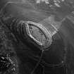
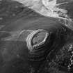
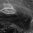
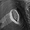
White Caterthun


Ring Ditch House (Prehistoric)
Site Name White Caterthun
Classification Ring Ditch House (Prehistoric)
Canmore ID 68705
Site Number NO56NW 43.01
NGR NO 5489 6601
Datum OSGB36 - NGR
Permalink http://canmore.org.uk/site/68705


- Council Angus
- Parish Menmuir
- Former Region Tayside
- Former District Angus
- Former County Angus
Field Visit (29 September 1989)
NO56NW 43.01 5489 6601.
The southerly of the two houses adjacent to the White Caterthun fort, this ring-ditch house measures 12.4m from NE to SW by 12m over a shallow ditch about 2.5m in breadth. The entrance is probably marked by a gap in the low external bank that is visible around the downslope side of the ring-ditch.
Visited by RCAHMS (SH) 29 September 1989.

