
Pricing Change
New pricing for orders of material from this site will come into place shortly. Charges for supply of digital images, digitisation on demand, prints and licensing will be altered.
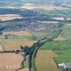
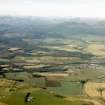
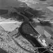
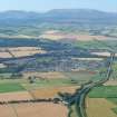
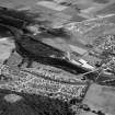
Maryburgh


Burgh (Medieval), Town (Period Unassigned)
Site Name Maryburgh
Classification Burgh (Medieval), Town (Period Unassigned)
Canmore ID 68550
Site Number NH55NW 41
NGR NH 540 561
NGR Description Centred NH 540 561
Datum OSGB36 - NGR
Permalink http://canmore.org.uk/site/68550


- Council Highland
- Parish Fodderty
- Former Region Highland
- Former District Ross And Cromarty
- Former County Ross And Cromarty
NH55NW 41 centred 540 561
REFERENCE: SCOTTISH RECORD OFFICE
Plan of the village of Maryburgh on the Estate of Brahan
ND GD46/20/Box 5

