
Greenock, Victoria Harbour


Dock (19th Century)
Site Name Greenock, Victoria Harbour
Classification Dock (19th Century)
Alternative Name(s) Greenock Harbour; Inner Firth Of Clyde; Inner Clyde Estuary; River Clyde; Clyde Ports
Canmore ID 68395
Site Number NS27NE 28
NGR NS 28605 75818
NGR Description Centred NS 28605 75818
Datum OSGB36 - NGR
Permalink http://canmore.org.uk/site/68395


- Council Inverclyde
- Parish Greenock
- Former Region Strathclyde
- Former District Inverclyde
- Former County Renfrewshire
NS27NE 28.00 centred 28605 75818
NS27NE 28.01 NS 2866 7598 Transit Shed.
Not to be confused with East India Harbour (centred NS 2853 7597) or Albert Harbour (centred NS 2781 7681), for which see NT27NE 32 and NT27NE 49 respectively.
East India Harbour [NAT]
OS 1:10,000 map, 1993.
Visible on vertical air photography, (OS 88/041/102, flown 1988).
(Undated) information in NMRS.
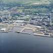
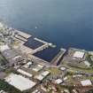
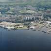
(Location cited as NS 287 759). Victoria Harbour, built 1846-50, engineer Joseph Locke. A rectangular basin formed by a pier shared with the East India Harbour, south and east quays, and two short piers at the seaward side. On the south quay is a single-storey, 3-bay hydraulic pumping station with a 3-storey accumulator tower, now disused. On the north quay is a 1-by-10-bay transit shed. The works are all ashlar.
J R Hume 1976.
Note (6 June 2017)
This harbour remains in use though the transit shed noted by Hume has been removed.
Information from HES, Survey and Recording (AKK) 2 April 2017.

