Accessibility

Font Size

100% 150% 200%

Background Colour

Default Contrast
Close Reset

Greenock, East Hamilton Street, James Watt Dock, Sugar Warehouse

Sugar Warehouse (19th Century)

Site Name Greenock, East Hamilton Street, James Watt Dock, Sugar Warehouse

Classification Sugar Warehouse (19th Century)

Alternative Name(s) Cartsdyke, Clyde Port Authority Warehouse; Greenock Harbour

Canmore ID 68370

Site Number NS27NE 15
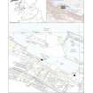
NGR NS 29828 75528

Datum OSGB36 - NGR

Permalink http://canmore.org.uk/site/68370

Ordnance Survey licence number AC0000807262. All rights reserved.
Canmore Disclaimer. © Bluesky International Limited 2025. Public Sector Viewing Terms

Toggle Aerial | View on large map

Digital Images

Greenock, James Watt Dock, oblique aerial view, taken from the SSW. Cappielow is visible in the foreground.
Greenock, James Watt Dock, oblique aerial view, taken from the SSW. Cappielow is visible in the foreground.Greenock, James Watt Dock, oblique aerial view, taken from the SSE.Oblique aerial view centred on the burnt out sugar warehouse and the docks, taken from the SW.Photograph from environment impact assessment at James Watt Dock, GlasgowSite location plan, illustration one accompanying report from watching brief at James Watt Dock, GlasgowFilm 1 ID image, photograph from watching brief at James Watt Dock, GlasgowGeneral view of the east end of the docks, photograph from watching brief at James Watt Dock, GlasgowNorth east corner of the docks, photograph from watching brief at James Watt Dock, GlasgowGeneral view of the docks, photograph from watching brief at James Watt Dock, GlasgowRails to the south side of the warehouse, photograph from watching brief at James Watt Dock, GlasgowInitial view of the culvert, photograph from watching brief at James Watt Dock, GlasgowInitial view of the culvert, photograph from watching brief at James Watt Dock, GlasgowDetail of the service culvert, during archaeological monitoring at James Warr Dock, GreenockOblique aerial view.Greenock, James Watt Dock, oblique aerial view, taken from the WSW. Cappielow is visible in the centre right of the photograph.Greenock, James Watt Dock, oblique aerial view, taken from the ENE. Cappielow is visible in the left centre of the photograph.Greenock, James Watt Dock, oblique aerial view, taken from the SSE.View from N.General view from SE.View of gable from NW.General view from WGeneral view of rear facade from dock to NEOblique aerial view centred on the burnt out sugar warehouse and the docks, taken from the S.Photograph from environment impact assessment at James Watt Dock, GlasgowPhotograph from environment impact assessment at James Watt Dock, GlasgowUnderside of the crane, photograph from watching brief at James Watt Dock, GlasgowView of the central quay, during archaeological monitoring at James Warr Dock, GreenockView of area cleared of cobbles (facing E), during archaeological monitoring at James Warr Dock, GreenockOblique aerial view of Cappielow Park, Cappielow Jetty, James Watt Dock and Sugar Warehouse, looking SW.Oblique aerial viewGreenock, James Watt Dock, oblique aerial view, taken from the W.Greenock, James Watt Dock, oblique aerial view, taken from the SSW. Cappielow is visible in the centre of the photograph.Greenock, James Watt Dock, oblique aerial view, taken from the SSW. Cappielow is visible in the foreground.Greenock, James Watt Dock, oblique aerial view, taken from the ESE. Cappielow is visible in the left centre of the photograph.Greenock, James Watt Dock, oblique aerial view, taken from the NE. Cappielow is visible in the centre of the photograph.Warehouse, East Hamilton Street, Cartsdyke, Greenock burghView of canopy from NW.Greenock, James Watt Dock, oblique aerial view, taken from the ENE. Cappielow is visible in the top left-hand corner of the photograph.Greenock, James Watt Dock, oblique aerial view, taken from the SW. Cappielow is visible in the bottom half of the photograph.Oblique aerial view centred on the burnt out sugar warehouse and the docks, taken from the ESE.Oblique aerial view centred on the burnt out sugar warehouse and the docks, taken from the E.Extract from 1857 OS map, illustration three accompanying report from watching brief at James Watt Dock, GlasgowGeneral view of the east end of the docks, photograph from watching brief at James Watt Dock, GlasgowView of the main crane, photograph from watching brief at James Watt Dock, GlasgowExcavations to the east side of the warehouse, photograph from watching brief at James Watt Dock, GlasgowOblique aerial viewGreenock, James Watt Dock, oblique aerial view, taken from the SW. Cappielow is visible in the centre right of the photograph.Greenock, James Watt Dock, oblique aerial view, taken from the SW. Cappielow is visible in the bottom half of the photograph.Greenock, James Watt Dock, oblique aerial view, taken from the SSW. Cappielow is visible in the centre of the photograph.View from SE.View of steel sliding door and cast-iron framed windows.Greenock, James Watt Dock, oblique aerial view, taken from the SSW. Cappielow is visible in the centre of the photograph.General view from WCentral block, view  from SW, Sugar Ware House, James Watt Dock, GreenockGeneral view from SEOblique aerial view centred on the burnt out sugar warehouse and the docks, taken from the WNW.Oblique aerial view centred on the football ground, taken from the NE.Greenock Harbour, Bridgend, Greenock, Renfrewshire, Scotland, 1949. Oblique aerial photograph taken facing west.  This image has been produced from a crop marked negative.Historic etching of James Watt Dock, illustration two accompanying report from watching brief at James Watt Dock, GlasgowExtract from 1897 OS map, illustration four accompanying report from watching brief at James Watt Dock, GlasgowView of the road at the east end of the site, photograph from watching brief at James Watt Dock, GlasgowGeneral view of the east end of the docks, photograph from watching brief at James Watt Dock, GlasgowView of the rails to the north side of the warehouse, photograph from watching brief at James Watt Dock, GlasgowCobble surface to the west side of the warehouse, photograph from watching brief at James Watt Dock, GlasgowGeneral view of the crane, photograph from watching brief at James Watt Dock, GlasgowGeneral view of the docks, photograph from watching brief at James Watt Dock, GlasgowCentral pier of the docks, photograph from watching brief at James Watt Dock, GlasgowView of the culvert, photograph from watching brief at James Watt Dock, GlasgowPhotograph from watching brief at James Watt Dock, GlasgowView of listed cantilever crane, during archaeological monitoring at James Warr Dock, GreenockView of the rail tracks and cobble quay, during archaeological monitoring at James Warr Dock, GreenockArea cleared of cobbles (facing N), during archaeological monitoring at James Warr Dock, GreenockWarehouse, East Hamilton Street, Cartsdyke, Greenock burghWarehouse, East Hamilton Street, Cartsdyke, Greenock burghInterior.
View of cast-iron frame.General view from NW.
Digital image of B 45831General view of the east end of the docks, photograph from watching brief at James Watt Dock, GlasgowInternal view of the culvert, photograph from watching brief at James Watt Dock, GlasgowPhotograph from watching brief at James Watt Dock, GlasgowOblique aerial viewOblique aerial view.Greenock, James Watt Dock, oblique aerial view, taken from the S. Cappielow is visible in the left centre of the photograph.View from SEGeneral view of the east end of the docks, photograph from watching brief at James Watt Dock, GlasgowView of an old boat, photograph from watching brief at James Watt Dock, GlasgowWest side of the warehouse, photograph from watching brief at James Watt Dock, GlasgowEast end of the docks, photograph from watching brief at James Watt Dock, GlasgowSouth elevation of the warehouse, photograph from watching brief at James Watt Dock, GlasgowInternal view of the culvert, photograph from watching brief at James Watt Dock, GlasgowInternal view of the culvert, photograph from watching brief at James Watt Dock, GlasgowGreenock, James Watt Dock, oblique aerial view, taken from the S. Cappielow is visible in the centre of the photograph.Greenock, James Watt Dock, oblique aerial view, taken from the NE. Cappielow is visible in the left centre of the photograph.Greenock, James Watt Dock, oblique aerial view, taken from the NNE. Cappielow is visible at the top edge of the photograph.View from SE.View from N.
Digital image of B 45832Oblique aerial view.View from WView of rear facade from dock to NEOblique aerial view centred on the burnt out sugar warehouse and the docks, taken from the NNE.Photograph from environment impact assessment at James Watt Dock, Glasgow

First 100 images shown. See the Collections panel (below) for a link to all digital images.

Administrative Areas

  • Council Inverclyde
  • Parish Greenock
  • Former Region Strathclyde
  • Former District Inverclyde
  • Former County Renfrewshire

Archaeology Notes

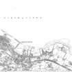
NS27NE 15 29828 75528

Location formerly entered as NS 2982 7552.

For James Watt Dock (NS 29677 75697), see NS27NE 17.00.

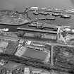
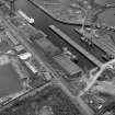
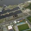
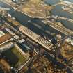
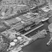
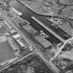
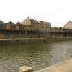
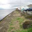
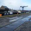
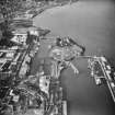
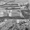
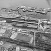
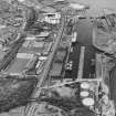
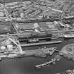
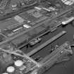
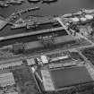
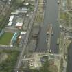
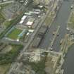
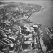
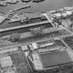
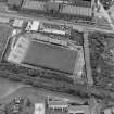
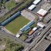
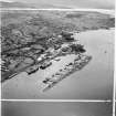
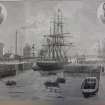
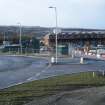
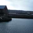
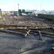
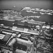
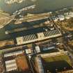
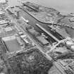
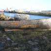
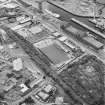
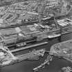
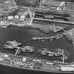
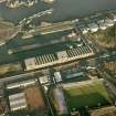
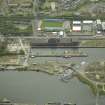
(Location cited as NS 297 757). James Watt Dock [NS27NE 17.00], 1879-86, engineer W R Kinipple. A roughly rectangular gated basin, with a short pier at the E end giving additional berthage.

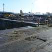
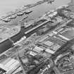
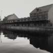
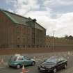
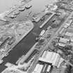
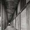
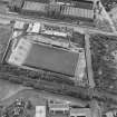
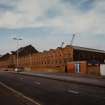
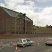
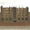
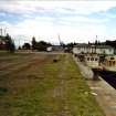
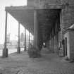
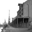
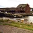
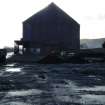
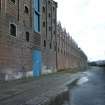
Along the S quay is a fine range of red- and white-brick warehouses [NS27NE 15], with two 5-storey and attic, 7-bay blocks, with central hoists, and two 3-storey and attic, one 9-bay, the other 11. The lower buildings have ridged roofs, with circular windows in the attics.

Immediately adjacent to the N are the Great Harbour (NS37NW 18.00), 1880 on, and the Garvel Graving Dock (1871), engineer W R Kinipple.

J R Hume 1976.

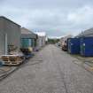
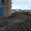
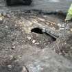
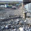
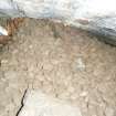
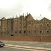
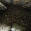
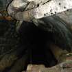
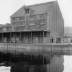
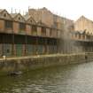
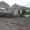
This raw sugar warehouse (c. 1885) is now disused.

Information from RCAHMS (MKO) 14 August 1995

Site Management (3 November 1997)

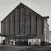
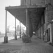
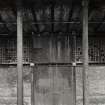
Long warehouse, with high first storey, built of red brick with arches, pilaster-strips and window-margins in yellow brick. At west end is a 4-storey and loft block 7 bays wide, the bays being separated by pilaster-strips; Central bay has door at 2nd, 3rd, 4th, with hoist over. To East of this block is a 2-storey, 18-bay range; windows are grouped in recessed arches in 9 pairs each with gable over (containing circular window). To East of this range is another 4-storey, 7-bay block followed by another 2-storey range, 22 bays wide, windows grouped in 11 pairs, the E. end having 6 recessed arches. The gable-ends of the 4-storey blocks have 8 stepped recessed arches.

Built beside the contemporary James Watt Dock which was built by John Waddell Edinburgh to the design of W R Kinniple. Upgraded to Cat A, 20/3/87.(Historic Scotland)
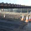
Activities

Project (2008)

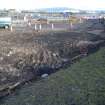
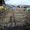
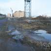
An impact assessment was undertaken by Headland Archaeology in 2008.

Headland Archaeology 2008

References

MyCanmore Image Contributions


Contribute an Image

MyCanmore Text Contributions