
Camelon - Ardoch - Strageath - Cargill Roman Road


Quarry Pit(S) (Roman), Roman Road (Roman)
Site Name Camelon - Ardoch - Strageath - Cargill Roman Road
Classification Quarry Pit(S) (Roman), Roman Road (Roman)
Alternative Name(s) Rr 9a; Culdees Castle Policies; Cuiltburn; Caerlaverock; Pirnhill Plantation
Canmore ID 68178
Site Number NN81NE 76
NGR NN 890 171
NGR Description NN 8734 1500 to NN 8964 1814
Datum OSGB36 - NGR
Permalink http://canmore.org.uk/site/68178


- Council Perth And Kinross
- Parish Muthill
- Former Region Tayside
- Former District Perth And Kinross
- Former County Perthshire
NN81NE 76 8875 1659 to 8911 1742
See also NN81NE 97.
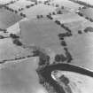
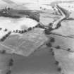
The main road turns N from Strageath for about 600 yards and crosses the River Earn by the disused Creel Ford.
D Christison 1900.
There is a curious pattern of roads leading out of the fort at Strageath, which would support the theory that they pre-dated the main road, the latter therefore having to adapt its course to them. It is possible, despite cultivation over a long period of time, to trace the roads by a combination of observation on the ground and from the air. Approximately 720 feet N of the north gate of Strageath the main road links with the road leaving that gate of the fort. It then heads in a NE direction, Margary (1957) considering that it may possibly have been planned to run paralle with the edge of the Highland zone. It seems that this was the end of the road's line N and it is likely that branch roads may have been planned from this point, although no traces have yet been found. There is considerable uncertainty as to where the Roman road crossed the River Earn. Roy (1747-55), Christison (1900) and later the OS, consider the location to have been the disused Creel Ford, which has now been obliterated due to the Pow Water having been canalized. However, Crawford and Margary consider this as unlikely and believe that it was more likely to have been near Innerpeffray, where a ford existed into the twentieth century.
W Roy 1747-55.
D Christison 1900; O G S Crawford 1939; I D Margary 1957.
The exact point where the R. Earn was crossed is not certainly known, but was very likely near Innerpeffray, E of the fort at Strageath (NN81NE 2).
O G S Crawford 1949
(NN 8697 1445 - )
NN 8745 1500, NN 8757 1554 no signs
NN 8757 1554 stony
NN 8757 1554, NN 8786 1574 mound visible
NN 8788 1575, NN 8811 1597 not seen
NN 8819 1605, NN 8845 1622 very doubtful traces
NN 8858 1632 mound
NN 8864 1643 very doubtful traces
NN 8876 1659 very well preserved, broad and plainly visible
NN 8873 1662 quarry-pits
NN 8884 1681 23ft wide at top and 27ft overall
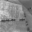
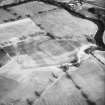
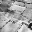
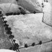
NN 8885 1681, NN 8910 1739 causeway clearly visible on RAF vertical aerial photographs (541/A/482 frames 3205-6)
NN 8932 1789 visible for 400ft on either side of the road. Visible in 1925 in the field SW of the road as a broad raised causeway.
NN 8937 1800 Bend quite accurately shown, mound visible but Roman road is best shown by curving belt six paces wide of lighter yellowish corn; rest being dark green, after a spell of one month without rain. At bend here there is certainly no sign of any other road coming in either from N or W. The Roman ridge here is seen quite plainly as a lighter coloured stony patch.
NN 8960 1804 junction with RR9b (Strageath to Cargill) appears to be further E than OS shows. See RAF vertical aerial photogrpahs (541/A/482 frames 3025-6)
OGS Crawford, 1949.
A Roman Road, 41 miles long, runs from Strageath to Kirriemuir. It runs eastward from Strageath crossing the R. Earn at an unidentified point and proceeding along the Gask Ridge where it is accompanied by a series of ten signal stations. It then heads NE to the Roman fort Bertha (NO02NE 25), crosses the R Tay and traverses Grassy Walls camp (NO12NW 8).
Between here and Cardean (NO24NE 12) it is intermittently visible, and from Cardean it ran to Kirriemuir.
I D Margary 1957
(NN 8674 1403)
NN 8735 1500 - NN 8775 1561 no trace
NN 8756 1530 - 8761 1544 no evidence of terrace across fairly steep sided gully.
NN 8775 1561 - NN 8786 1574 slight mound evident (see NN 8715)
NN 8787 1575 - NN 8810 1597 no trace
NN 8811 1598 - NN 8822 1609 remains of ornamental avenue , 7.5m wide, partly on course of Roman Road
NN 8824 1610 - NN 8873 1657 no trace
NN 8825 1658 - NN 8895 1706 causeway discernible but occupied by forestry way and partly overgrown by gorse
NN 8895 1706 - NN 8901 1707 course obscured by afforestation
(NN 8901 1707 - 8902 1709 destroyed by railway cutting)
NN 8902 1709 - NN 8911 1741 extant
NN 8911 1741 - NN 8941 1801 no trace
NN 8941 1801 - hump quite clear at fence
NN 8941 1801 - NN 8957 1803 no trace
NN 8957 1803 - extant
Information from OS (EGC) May and June 1967
NN 8973 1800 to NN 8960 1804 and NN 8960 1804 to NN 8964 1814 Roman road is clearly visible on RAF vertical aerial photographs (541/A/482 frame no. 3024-5, 1949) and St. Joseph's CUCAP aerial photographs (DE079, 083 and 084) as light marks.
From NN 8964 1814 the course of the road is uncertain (WDJ).
NN 8964 1814 to NN 8984 1835 and NN 8980 1806 to NN 8984 1835 See aerial photographs in Crawford (1949, Plate V).
NN 8973 1823 to NN 8974 1824 A short light cropmark can be observed on St Joseph's CUCAP aerial photograph (DG083).
NN 8984 1935 to NN 8999 1848 No trace of the road is visible in this field on the OS Record 6 inch map (Crawford).
Possible alternate crossings over R Earn:
NN 8964 1814 to NN 8972 1857 There is no sign of the road up to the potential crossing point (at NN 8972 1857). This crossing point is uncertain. Roy (1793) is probably wrong in putting it at the disused Creel Ford. Innerpeffray Ferry is a more likely place (see NN91NW 146 at NN 9010 1842) (Crawford 1949).
NN c. 8995 1827 Dark cropmarks are observed in St Joseph's CUCAP aerial photograph (JQ05). This may possibly lead to the crossing point on NN91NW 146 (at NN 9113 1828).
Visited by OS (WDJ) May 1967
Information from O G S Crawford 1940
O G S Crawford 1949; W Roy 1793
There is no obvious reason why the road should run to Kirriemuir since there is no known Roman site there.
There is equally no obvious reason why the road should not have run from Flavian Cardean via the line of the modern road to NO 3251 4823 and continued on this line which leads directly for the Flavian camp at Finavon (NO45NE 22), 13 and a half miles away. From there it would presumably continue to the Flavian site at Stracatho (NO66NW 18).
Information from OS (ES) 1973.
The length of this road between NN 8901 1718 and NN 8910 1739 is scheduled as 'Cuiltburn, Roman road'.
Information from Historic Scotland, scheduling document dated 3 July 2000.
The length of this road between NN c. 8899 1715 and NN c. 8875 1659 (through Pirnhill Plantation) is scheduled as 'Caerlaverock, Roman road'.
Information from Historic Scotland, scheduling document dated 28 November 2005.
Field Visit (26 November 1997)
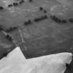
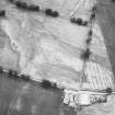
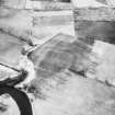
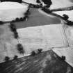
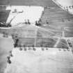
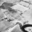
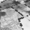
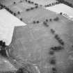
NN 8903 1725 In rough pasture to the NE of Pirnhill Plantation, a length of the Roman road that runs from Ardoch to Strageath (RR7) survives as a low cambered mound. The road extends from the disused railway line that skirts the plantation over a distance of some 200m to the NE (NN 8900 1718 to 8910 1738). The northen part is covered by dense gorse, making it difficult to trace, but the visible section to the S has a distinct camber, measuring between 7.5m and 8.5m in breadth, and rising to 0.75m in height in the centre. A drain is visible in places on either side. Several other features impinge on this section of road, including a trackway, a bank and an area of rig (see NN81NE 97).
(EARN96 16)
Visited by RCAHMS (PJD) 14 October 1996.
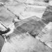
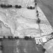
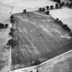
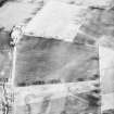
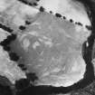
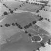
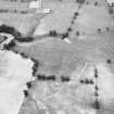
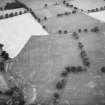
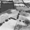
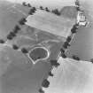
The line of the Roman road to Strageath is revealed by cropmarks on oblique aerial photographs in the grounds to the WSW of Culdees between NN 8800 1587 and NN 8811 1598. The road is visible as an intermittent mark up to 6m across, flanked by quarry pits that are set between 2m and 10m from the road and measure up to 8m across. Beyond the fence-line that marks the end of the cropmark section of the road, the road-line is visible on the ground as a flat-bottomed hollow, up to about 10m across, fading away close to the drive to the house (NN 8811 1598 to NN 8821 1608). This section of the road is partly flanked by low embankments, but these support some mature trees and may relate to the creation of the policies around Culdees. At the NE end of the tree-lined section, a short stretch of the road survives as a cambered mound about 20m in length, 7.5m in breadth, and 0.3m in height; this section which peters out about 30m from the drive to the house.
(EARNAP 123 and EARN96 15)
Visited by RCAHMS (DCC and PJD) 26 November 1997.

