
Following the launch of trove.scot in February 2025 we are now planning the retiral of some of our webservices. Canmore will be switched off on 24th June 2025. Information about the closure can be found on the HES website: Retiral of HES web services | Historic Environment Scotland
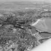
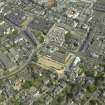
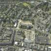
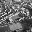
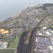
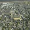
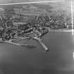
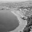
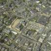
Kirkcaldy, General


Burgh (Medieval), Town (Period Unassigned)
Site Name Kirkcaldy, General
Classification Burgh (Medieval), Town (Period Unassigned)
Canmore ID 68091
Site Number NT29SE 57
NGR NT 2800 9100
Datum OSGB36 - NGR
Permalink http://canmore.org.uk/site/68091


- Council Fife
- Parish Kirkcaldy And Dysart
- Former Region Fife
- Former District Kirkcaldy
- Former County Fife
NT29SE 57 2800 9100
Kirkcaldy first appears as a burgh, dependent on the abbey of Dunfermline in a charter of Robert I 1315 x 1328; it became a royal burgh in 1644.
G S Pryde 1965.
NMRS REFERENCE:
See also:
Scottish Country Life
Volume V. No. 2
pp 66 - 71
February 1918
EXTERNAL REFERENCE:
'Recording the changing face of FIFE' (Edinburgh Tatler, March 1970)
Aerial Photography (1966)
Oblique aerial photographs of Ravenscraig Castle and the surrounding area of Kirkcaldy, Fife, photographed by John Dewar in 1966.

