|
Photographs and Off-line Digital Images |
B 11519 |
Alastair Maxwell-Irving |
Detail of gunloop in N wall. |
1993 |
Item Level |
|
|
Photographs and Off-line Digital Images |
B 11520 |
Alastair Maxwell-Irving |
NW angle, view along W wall. |
1993 |
Item Level |
|
|
Photographs and Off-line Digital Images |
B 11521 |
Alastair Maxwell-Irving |
View of W wall. |
1993 |
Item Level |
|
|
Photographs and Off-line Digital Images |
B 11522 |
Alastair Maxwell-Irving |
Detail of gunloop in N wall. |
1993 |
Item Level |
|
|
Photographs and Off-line Digital Images |
B 11523 |
Alastair Maxwell-Irving |
View of E wall, looking NW. |
1993 |
Item Level |
|
|
Photographs and Off-line Digital Images |
B 11524 |
Alastair Maxwell-Irving |
View inside NE corner, showing supports for lowest treads of wheelstair. |
1993 |
Item Level |
|
|
Photographs and Off-line Digital Images |
B 11525 |
Alastair Maxwell-Irving |
View of SW corner, from SE. |
1993 |
Item Level |
|
|
Photographs and Off-line Digital Images |
B 11526 |
Alastair Maxwell-Irving |
Detail of gunloop in W wall. |
1993 |
Item Level |
|
|
Photographs and Off-line Digital Images |
B 11527 |
Alastair Maxwell-Irving |
Detail of gunloop in W wall. |
1993 |
Item Level |
|
|
Photographs and Off-line Digital Images |
B 11528 |
Alastair Maxwell-Irving |
Section of W wall, showing gunloop. |
1993 |
Item Level |
|
|
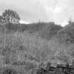
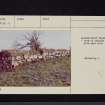
Photographs and Off-line Digital Images |
DF 4010 |
List C Survey |
View of rubble masonry. |
1975 |
Item Level |
|
|
Prints and Drawings |
DC 32351 |
Records of the Royal Commission on the Ancient and Historical Monuments of Scotland (RCAHMS), Edinbu |
Survey drawing; Plan of Auchinrivock bastle, indicating location of gunloop. |
13/8/1993 |
Item Level |
|
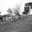 |
On-line Digital Images |
SC 384429 |
|
View of rubble masonry. |
|
Item Level |
|
 |
On-line Digital Images |
SC 1346165 |
Records of the Royal Commission on the Ancient and Historical Monuments of Scotland (RCAHMS), Edinbu |
Survey drawing; Plan of Auchenrivock Tower. |
13/8/1993 |
Item Level |
|
|
Photographs and Off-line Digital Images |
SC 1631609 |
List C Survey |
View of rubble masonry. |
1975 |
Item Level |
|
 |
On-line Digital Images |
SC 1979827 |
Scottish Development Department |
Auchenrivock Tower, Canonbie Parish |
8/1982 |
Item Level |
|
 |
On-line Digital Images |
SC 2472646 |
Records of the Ordnance Survey, Southampton, Hampshire, England |
Auchenrivock Tower, NY38SE 6, Ordnance Survey index card, page number 1, Recto |
1958 |
Item Level |
|
 |
On-line Digital Images |
SC 2472647 |
Records of the Ordnance Survey, Southampton, Hampshire, England |
Auchenrivock Tower, NY38SE 6, Ordnance Survey index card, page number 2, Verso |
1958 |
Item Level |
|
 |
On-line Digital Images |
SC 2472648 |
Records of the Ordnance Survey, Southampton, Hampshire, England |
Auchenrivock Tower, NY38SE 6, Ordnance Survey index card, Recto |
1958 |
Item Level |
|
 |
On-line Digital Images |
SC 2472649 |
Records of the Ordnance Survey, Southampton, Hampshire, England |
Auchenrivock Tower, NY38SE 6, Ordnance Survey index card, Recto |
1958 |
Item Level |
|
|
All Other |
551 166/1/1 |
Records of the Ordnance Survey, Southampton, Hampshire, England |
Archaeological site card index ('495' cards) |
1947 |
Sub-Group Level |
|


