
Auchenrivock Tower


Fortified House (16th Century) - (17th Century), Tower House (Medieval)(Possible)
Site Name Auchenrivock Tower
Classification Fortified House (16th Century) - (17th Century), Tower House (Medieval)(Possible)
Alternative Name(s) Stakeheugh; Stakeheuch; Auchinrivock
Canmore ID 67708
Site Number NY38SE 6
NGR NY 37215 80500
Datum OSGB36 - NGR
Permalink http://canmore.org.uk/site/67708


- Council Dumfries And Galloway
- Parish Canonbie
- Former Region Dumfries And Galloway
- Former District Annandale And Eskdale
- Former County Dumfries-shire
NY38SE 6 3721 8050
(NY 3721 8049) Auchenrivock Tower (NR) (Remains of) (NAT)
OS 6" map (1957)
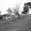
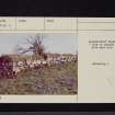
Built of irregular boulders and now forming part of the garden wall to the N of adjoining farm buildings, the remains of Auchenrivock Castle, earlier Stakeheugh (J and R Hyslop 1912), measure 33 1/4 ft N-S over walls 4ft thick and 7ft high, the N wall 13 1/2ft, and the S 10ft long. Shot holes remain in the N and S walls.
This was the original seat of the Irving family and was burnt by Sir Christopher Dacre in 1513.
RCAHMS 1920, visited 1912
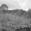
NY 3721 8050. The decaying remains of Auchenrivock Tower are now obscured by dense vegetation. The W wall is 9.4m long, 1.6m high internally and 0.9m high externally. The return walls are 4.0m and 3.0m long respectively; a single shot hole survives in both the N and W walls (but not in the S wall).
Visited by OS (MJF) 10 October 1979.
Tower [NR] (remains of) [NAT]
OS 1:10,000 map, 1983.
Only a fragment now remains of a tower of the Irvines originally called Stakeheugh. It or a previous tower on this site was burnt in 1513 by Christopher Dacre.
M Salter 1993.
Field Visit (16 July 1912)
Auchenrivock Castle.
This fragment stands at a considerable elevation on the south side of the main road to Canonbie and some 3 miles from Langholm. It is built of irregular boulders and now forms part of the garden wall to the north of the adjoining farm-buildings. It measures 33 feet 3 inches from north to south over walls averaging 4 feet in thickness and 7 feet in height. The north and south walls are respectively 13 feet 6 inches and 10 feet in length. Shot-holes, one in the north wall and another in the west wall, with splayed outer and inner jambs and with circular openings some 4 ½ inches in diameter, are the only features now remaining. The inner surface of the western wall is very indefinite, but it seems. probable that the basement was vaulted.
This place, near the Irvine Burn where it falls into the Esk, was of old known as Stakeheugh (1), and was the original seat of the Irving family. In October 1513 Sir Christopher Dacre burned "the Stakehugh, the manor place of Irewyn, and the hamlets down Irewyn Burn" (2).
RCAHMS 1920, visited 4 July 1912.
(1) Langholm as It Was, p. 353
(2) Letters and Papers, For. and Dom. Henry VIII., i. No. 4529.
Field Visit (March 1981)
Auchenrivock NY 372 805 NY38SE 6
All that remains of this tower, formerly known as Stakeheuch, are fragments of the N, S and W walls.
RCAHMS 1981, visited March 1981.
(Hyslop and Hyslop 1912, 320, 353-6; RCAHMS 1920, p. 27, No. 44).
Measured Survey (13 August 1993)
RCAHMS surveyed Auchenrivock Tower on 13 August 1993 with plane-table and alidade, producing a plan at a scale of 1:250.
Field Visit (March 1993)
NY 3721 8050 NY38SE 6
The remains of this building, which is probably a fortified house of late 16th- or 17th-century date, lie to the rear of a garden plot on the NW side of Auchenrivock steading (NY38SE 79), from where it would have enjoyed a particularly fine psospect across the valley towards Broomholm (NY38SE 80). The house was rectangular on plan, measuring 10.3m from N to S by 4.1m transversely over walls up to 0.9m thick and 1.7m high where best preserved (at the N end); the greater part of the E wall and part of the adjoining S wall have been removed by robbing. The interior was divided into two compartments, the smaller, on the N, containing a newel-stair of which only the cut-back treads remain. A chamber beneath the stair was lit by a small circular loophole in the N wall. The main apartment at ground floor level was vaulted with a loophole in the W wall (piercing the haunch of the vault and of the same type as that in the N wall) and a mural recess with splayed jambs (possibly a flue) towards the W end of the S wall.
The house possibly occupies the site of the tower-house that was the original seat of the Irving family and was burnt by Sir Christopher Dacre in 1513.
Visited by RCAHMS (IMS), March 1993.
Listed as tower.
RCAHMS 1997.

