
River Dyke


Shieling Hut(S) (Post Medieval)
Site Name River Dyke
Classification Shieling Hut(S) (Post Medieval)
Canmore ID 6769
Site Number NC84NE 14
NGR NC 850 470
Datum OSGB36 - NGR
Permalink http://canmore.org.uk/site/6769


- Council Highland
- Parish Farr
- Former Region Highland
- Former District Sutherland
- Former County Sutherland
NC84NE 14 850 470.
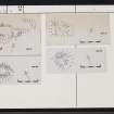
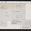
A minor upland farmstead consisting of a series of tiny rectilinear and oval structures. There are two small patches of improved grass cover, but no large-scale land improvement is associated with the settlement.
R J Mercer 1980.
Seven unroofed shieling-huts, three to the N of the river and four to the S, are depicted on the 1st edition of the OS 6-inch map (Sutherland 1878, sheet xxxvii). Three unroofed shieling-huts, to the S of the river, are shown on the current edition of the OS 1:10,560 map (1962).
Information from RCAHMS (SAH) 23 August 1995

