|
Prints and Drawings |
CAD 80/1 |
|
Location map (E Area) Pub.Rep. p49 - Outsize drawing. |
1979 |
Item Level |
|
|
Prints and Drawings |
CAD 80/10 |
|
Location map 1:10560 |
1979 |
Item Level |
|
|
Prints and Drawings |
CAD 80/2 |
|
OS maps Xerox 1:10560 |
1979 |
Item Level |
|
|
Prints and Drawings |
CAD 80/64 |
|
Miscellaneous plans |
|
Item Level |
|
|
Prints and Drawings |
CAD 80/65 |
|
Miscellaneous plans |
|
Item Level |
|
|
Prints and Drawings |
CAD 80/66 |
|
Miscellaneous plans |
|
Item Level |
|
|
Manuscripts |
MS 121/17 |
|
Forsinard and Halladale Field Survey Report and Gazetteer Mercer 1979 |
|
Item Level |
|
|
Manuscripts |
MS 121/18 |
|
Ms copy of gazetteer |
|
Item Level |
|
|
Manuscripts |
MS 121/19 |
|
Record forms |
|
Item Level |
|
|
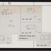
Prints and Drawings |
CAD 80/15 |
|
Plans Mons.24-34 |
1979 |
Item Level |
|
|
Prints and Drawings |
CAD 80/16 |
|
Ink plans Mons.24-34 1:50 |
|
Item Level |
|
|
Prints and Drawings |
CAD 80/17 |
|
Ink plans Mons.24-34 1:50 |
|
Item Level |
|
|
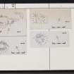
Prints and Drawings |
CAD 80/19 |
|
Pencil and ink plans. 1:50,1:500 |
|
Item Level |
|
|
Prints and Drawings |
CAD 80/20 |
|
Pencil and ink plans. 1:50,1:500 |
|
Item Level |
|
 |
On-line Digital Images |
SC 2350070 |
Records of the Ordnance Survey, Southampton, Hampshire, England |
River Dyke, NC84NE 14, Ordnance Survey index card, Recto |
1958 |
Item Level |
|
 |
On-line Digital Images |
SC 2350071 |
Records of the Ordnance Survey, Southampton, Hampshire, England |
River Dyke, NC84NE 14, Ordnance Survey index card, Recto |
1958 |
Item Level |
|
 |
On-line Digital Images |
SC 2350072 |
Records of the Ordnance Survey, Southampton, Hampshire, England |
River Dyke, NC84NE 14, Ordnance Survey index card, Recto |
1958 |
Item Level |
|
 |
On-line Digital Images |
SC 2350073 |
Records of the Ordnance Survey, Southampton, Hampshire, England |
River Dyke, NC84NE 14, Ordnance Survey index card, Verso |
1958 |
Item Level |
|


