
Tanlawhill


Farmstead (Medieval) - (Post Medieval), Kiln (Medieval) - (Post Medieval), Quarry Scoop(S) (Period Unknown), Tower House (16th Century)
Site Name Tanlawhill
Classification Farmstead (Medieval) - (Post Medieval), Kiln (Medieval) - (Post Medieval), Quarry Scoop(S) (Period Unknown), Tower House (16th Century)
Alternative Name(s) Tanlaw Hill; Hind Fell; 'john Batie Of Tanlaw Hill'
Canmore ID 67392
Site Number NY29SW 25
NGR NY 2370 9105
Datum OSGB36 - NGR
Permalink http://canmore.org.uk/site/67392


- Council Dumfries And Galloway
- Parish Eskdalemuir
- Former Region Dumfries And Galloway
- Former District Annandale And Eskdale
- Former County Dumfries-shire
Remains of Medieval / post-medieval settlement and possible tower house, located within rough pasture on northeast facing slopes of Hind Fell overlooking the Black Esk, within Tanlawhill ASA. Restricted views to within valley to north and east. Relatively localised setting.
information from Héléna Gray, (CFA Archaeology Ltd), August 2015
OASIS ID: cfaarcha1-278420
NY29SW 25 2370 9105
See also NY29SW 26.
It is traditionally said that there was a hunting lodge at Tanlawhill (NY 237 912). Moll's map, published in 1745, shows a tower there and a stone, brought from Tanlawhill, and carved with the royal arms of Scotland is now on one of the cottage doors at Berrycar. (Berryscaur: NY 161907). (However, see NY29SW 26).
J and R Hyslop 1912
There is no trace of an early building at Tanlawhill. Several dressed stones, however, and a sandstone lintel dated 1659 (now built into the front wall of the house) have been discovered in the grounds. These finds, together with the documentary evidence tend to confirm the existence of an earlier building of some importance at this site. It is not possible to determine whether the lintel at Berryscaur came from Tanlawhill or Westside (see NY29SW 26).
Visited by OS (BS) 17 October 1978
An enclosure, which is marked by pecked lines, and a circular Sheepfold are depicted on the 1st edition of the OS 6-inch map (Dumfriesshire 1862, sheet xxxv). Three enclosures, two of which are incomplete, are shown on the current edition of the OS 1:10000 map (1982).
Information from RCAHMS (SAH), 16 June 2000.
Field Visit (July 1980)
Tanlawhill NY 237 910 NY29SW 25
On a broad shelf on the NE flank of Hind Fell, 250m S of Tanlawhill and adjacent to five contiguous turf-banked enclosures, there are the remains of eight rectangular buildings, two substantial stone structures and a kiln. Six of the buildings are platform-buildings, two set parallel to the contours, and one of the stone structures may be the remains of a small tower.' John Batie of Tanlaw Hill' is on record in 1598/9, and the settlement is shown in Blaeu's Atlas of 1654; it was abandoned early in the 19th century. A lintel found 'in the grounds' of Tanlawhill and now built into the modern house bears the date 1659, the initials MIR and a coat of arms bearing (? for Riddell) a chevron between three ears of rye; the initials and date M G G and 1719 have been added.
RCAHMS 1980, visited July 1980
(Blaeu 1654; SRO, RHP 9629; NM RS, DFD/157 /1; OS 6-inch map, Dumfriesshire, 1st ed., 1862, sheet xxxv; Hyslop and Hyslop 1912, 301, 571-2; OS Record Card NY 29 SW 25)
Measured Survey (18 July 1991 - 19 July 1991)
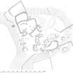
RCAHMS surveyed the tower house and farmstead at Tanlawhill with plane-table and self-reducing alidade at a scale of 1:500 between 18-19 July 1991. The plan was checked on site on 16 March 1994 and later redrawn in ink and published at a scale of 1:1000 (RCAHMS 1997, Fig. 229).
Field Visit (September 1992)
NY 237 910 NY29SW 25
The wasted remains of a small tower-house and the grass-grown wall-footings of its associated buildings are situated on a broad natural shelf overlooking the farmsteading of Tanlawhill (NY29SW 91.00) some 250m to the N. The tower-house, which is adjoined on the SE by a rectangular enclosure, has been so extensively robbed that its exact dimensions cannot be determined, and it now appears as a rectangular structure about 9m across defined by a band of mortared wall-core up to 0.5m high. Immediately to the NW three rectangular buildings have been loosely ranged to create a rudimentary yard, and to the rear of these a further three buildings have been set end-on to the hillslope which defines the W limit of the natural shelf. On the N the site is bounded by five contiguous turf-banked enclosures, the largest containing the footings of four rick-stances and a later circular stell and adjoined on the S by a seventh building; a kiln has been set into the hillslope to the W. Disposed around the periphery of the site there are a number of small quarry pits.
Visited by RCAHMS (PC), September 1992
Listed as tower and farmstead.
RCAHMS 1997
Project (29 May 2014)
An archaeological evaluation was undertaken by CFA Archaeology Ltd, a desk based assessment and walk over survey (May 29th 2014) was conducted
The historic environment record within the Site Boundary is relatively limited, although there is some potential for the proposed development site to contain previously unknown heritage assets from at least the later prehistoric period onwards, given the historic landscape character of the wider area. Taking this into account, the archaeological potential of the proposed development site is considered to be low.
A summary assessment, on a site by site basis, of the predicted effects on the settings of assets within a 10km radius where the blade tip ZTV indicates that there would be theoretical views of one or more turbines
information from Héléna Gray, (CFA Archaeology Ltd), August 2015
OASIS ID: cfaarcha1-278420

