 |
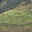
On-line Digital Images |
SC 337198 |
|
|
|
Item Level |
|
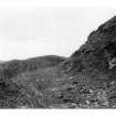 |
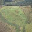
On-line Digital Images |
SC 380412 |
|
Rampart and ditch. |
|
Item Level |
|
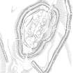 |
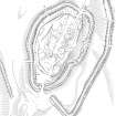
On-line Digital Images |
SC 381981 |
Records of the Royal Commission on the Ancient and Historical Monuments of Scotland (RCAHMS), Edinbu |
Plan of Castle O'er fort and adjacent lengths of linear earthwork, redrawn for publication from DC 32458. |
8/9/1995 |
Item Level |
|
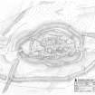 |
On-line Digital Images |
SC 1354839 |
Records of the Royal Commission on the Ancient and Historical Monuments of Scotland (RCAHMS), Edinbu |
Survey drawing; Plan of Castle O'er, fort. |
13/4/1993 |
Item Level |
|
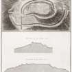 |
On-line Digital Images |
DP 192282 |
|
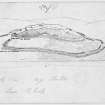
Plan and sections of Castle Over in Eskdale Moor supposed to be the uxellum of the Romans. Plate XXVI. Reproduced from William Roy. The military antiquities of the Romans in Britain, 1793. |
|
Item Level |
|
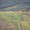 |
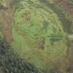
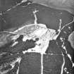
On-line Digital Images |
DP 264001 |
Historic Environment Scotland |
Oblique aerial view. |
29/8/2017 |
Item Level |
|
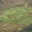 |
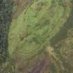
On-line Digital Images |
DP 264002 |
Historic Environment Scotland |
Oblique aerial view. |
29/8/2017 |
Item Level |
|
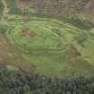 |
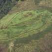
On-line Digital Images |
DP 264003 |
Historic Environment Scotland |
Oblique aerial view. |
29/8/2017 |
Item Level |
|
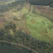 |
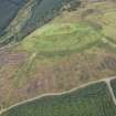
On-line Digital Images |
DP 264004 |
Historic Environment Scotland |
Oblique aerial view. |
29/8/2017 |
Item Level |
|
 |
On-line Digital Images |
DP 264005 |
Historic Environment Scotland |
Oblique aerial view. |
29/8/2017 |
Item Level |
|
 |
On-line Digital Images |
DP 264006 |
Historic Environment Scotland |
Oblique aerial view. |
29/8/2017 |
Item Level |
|
 |
On-line Digital Images |
DP 264007 |
Historic Environment Scotland |
Oblique aerial view. |
29/8/2017 |
Item Level |
|
 |
On-line Digital Images |
DP 264008 |
Historic Environment Scotland |
Oblique aerial view. |
29/8/2017 |
Item Level |
|
 |
On-line Digital Images |
DP 264009 |
Historic Environment Scotland |
Oblique aerial view. |
29/8/2017 |
Item Level |
|
 |
On-line Digital Images |
DP 264010 |
Historic Environment Scotland |
Oblique aerial view. |
29/8/2017 |
Item Level |
|
 |
On-line Digital Images |
DP 264011 |
Historic Environment Scotland |
Oblique aerial view. |
29/8/2017 |
Item Level |
|
 |
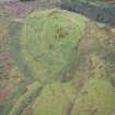
On-line Digital Images |
SC 1761028 |
RCAHMS Aerial Photography |
Oblique aerial view. |
1980 |
Item Level |
|
 |
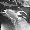
On-line Digital Images |
SC 1761171 |
RCAHMS Aerial Photography |
Oblique aerial view. |
1980 |
Item Level |
|
 |
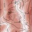
On-line Digital Images |
SC 1917405 |
Records of the Royal Commission on the Ancient and Historical Monuments of Scotland (RCAHMS), Edinbu |
Upper Eskdale landscape case-study area: map showing the prehistoric monuments, with windows for maps of Bailiehill and Raeburnfoot. Published in Eastern Dumfriesshire: an archaeological landscape. |
11/1996 |
Item Level |
|
 |
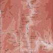
On-line Digital Images |
SC 1917406 |
Records of the Royal Commission on the Ancient and Historical Monuments of Scotland (RCAHMS), Edinbu |
Column-width map showing the extent of the system of linear earthworks around the fort at Castle O'er. Published in Eastern Dumfriesshire: an archaeological landscape. |
1996 |
Item Level |
|
 |
On-line Digital Images |
SC 1917711 |
Records of the Royal Commission on the Ancient and Historical Monuments of Scotland (RCAHMS), Edinbu |
Publication drawing; Plan of Castle O'er fort and adjacent lengths of linear earthwork. |
8/9/1995 |
Item Level |
|
 |
On-line Digital Images |
DP 378539 |
Records of the Royal Commission on the Ancient and Historical Monuments of Scotland (RCAHMS), Edinbu |
Survey drawing; plan of fort at Castle O'Er |
8/1980 |
Item Level |
|
 |
On-line Digital Images |
DP 380549 |
Records of the Royal Commission on the Ancient and Historical Monuments of Scotland (RCAHMS), Edinbu |
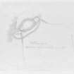
Publication drawing; perspective sketch showing key elements, Castle O'er (RCAHMS 1920 fig. 57) |
c. 1912 |
Item Level |
|
 |
On-line Digital Images |
DP 380550 |
Records of the Royal Commission on the Ancient and Historical Monuments of Scotland (RCAHMS), Edinbu |
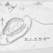
Publication drawing; plan of fort, Castle O'er (RCAHMS 1920 fig. 58) |
c. 1912 |
Item Level |
|


