
Pricing Change
New pricing for orders of material from this site will come into place shortly. Charges for supply of digital images, digitisation on demand, prints and licensing will be altered.
Camp Hill, Bailiehill


Building (Post Medieval), Fort (Prehistoric), Pen (Post Medieval), Settlement (Iron Age)
Site Name Camp Hill, Bailiehill
Classification Building (Post Medieval), Fort (Prehistoric), Pen (Post Medieval), Settlement (Iron Age)
Alternative Name(s) Bailiehill, Camp Hill
Canmore ID 67373
Site Number NY29SE 8
NGR NY 25580 90520
Datum OSGB36 - NGR
Permalink http://canmore.org.uk/site/67373


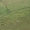
![Map of archaeological features in the landscape around Bailiehill: publication drawing for Inventory of Eastern Dumfriesshire, generated from computer file 5BAILHIL.ai. Unattributed, [1996].](http://i.rcahms.gov.uk/canmore/l/SC00372196.jpg)


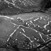

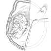
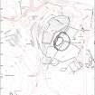


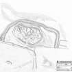
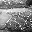
![Map of archaeological features in the landscape around Bailiehill: publication drawing for Inventory of Eastern Dumfriesshire, generated from computer file 5BAILHIL.ai. Unattributed, [1996].](http://i.rcahms.gov.uk/canmore/s/SC00372196.jpg)


- Council Dumfries And Galloway
- Parish Westerkirk
- Former Region Dumfries And Galloway
- Former District Annandale And Eskdale
- Former County Dumfries-shire
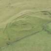
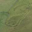
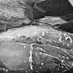
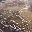
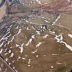
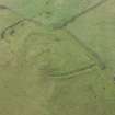
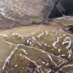
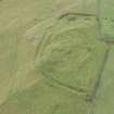
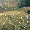
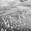
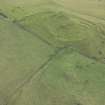
Well preserved remains of later prehistoric fort located within improved pasture on summit of Camp Hill, within Tanlawhill Hill ASA. Modern forestry plantation borders ASA. Strategically sited at Black Esk / White Esk / River Esk confluence (to the north, west and east. Main views are along these river valleys; more restricted to south-east and southwest due to local topography. Other related sites in near vicinity. Consented Ewe Hill Wind Farm visible in views to south-east.
information from Héléna Gray, (CFA Archaeology Ltd), August 2015
NY29SE 8 25580 90520
(NY 2558 9052) Camp (NR)
OS 6" map (1957)
At Bailiehill, an enclosure, 360' NE-SW by 160' and defended by two ramparts and a medial ditch, contains an inner enclosure about 150' in diameter within what appears to be a ruined wall of considerable thickness.
Without excavation, it is not possible to determine whether this was a defended settlement with an outer annexe, or an earlier site upon which a later walled settlement has been superimposed. The differences in the defences would seem to imply the latter, yet there is a distinct possibility that the whole represents one work, the inner enclosure formed by the wall and containing the occupants' timber-built huts being surrounded by a defended area, formed by the ramparts and ditch, the space between being usable as a pen for animals. This kind of arrangement has been noted in connection with palisaded works, and there is no reason why it should not have persisted into the period when this type of defence was used.
RCAHMS 1920, visited 1912; RCAHMS Marginal Lands Survey 1955; R W Feachem 1965; G Jobey 1971.
This fort is one of the many which occur in the stretch of Eskdale above Langholm. It lies on a hill beside the by-road which follows the valley of the Water of Milk from Annandale to Eskdale, reaching the latter at the point where the Black and White Esks come together. It is almost certainly a work of two main structural periods, the inner enclosure probably being the later. This almost circular, measuring about 150 ft (46m) within a stony bank which is probably a ruined wall. This is spread to a maximum thickness of 20 ft (6.1m) and stands 5 ft (1.5m) high.
The enclosure thus formed lies within a larger one measuring 360 ft (110m) by 160 ft (49m) within two massive ramparts with a median ditch. This work probably represents the original fort, and the walled enclosure may be an example of similar structures which, where found farther E, have long been assumed to belong to the immediate post-Roman period.
R W Feachem 1963.
This fort is generally as described and planned by Jobey. The interior is disturbed, and only four timber house sites were located. No entrance is visible through the outer defences, its SE half having been destroyed by cultivation.
Resurveyed at 1/2500.
Visited by OS (DWR), 18 October 1973.
No change to previous field report.
Surveyed at 1:10,000.
Visited by OS (BS), 13 October 1978.
Scheduled as 'Camp Hill, fort, 175m WSW of Bailiehill... the remains of a multi-phase fort or defended settlement...'
Information from Historic Scotland, scheduling document dated 25 June 2010.
Field Visit (14 July 1955)
Fort, Camp Hill (Inv. 640)
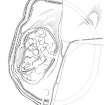
I suspect that this is a Dark Age fort consisting of a citadel (A), an inner ward (B), and an outer ward (C). Enclosures A and B have had stone walls though in most cases these have been heavily robbed. C, on the other hand, is bounded by a ditch with upcast banks on either side, strikingly reminiscent of the works at Bonchester Hill (NT51SE 10). The ditch of C is visible in the pasture field at D on the sketch and the rest of the missing circuit is suggested by vegetational marks on the air photographs. This is a site which should certainly be planned.
Visited by RCAHMS (KS) 14 July 1955
Field Visit (August 1980)
Camp Hill, Bailiehill NY 255 905 NY29SE 8
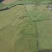
Situated on the summit of Camp Hill, there is a fort which measures 78m by 40m within its rampart, and contains at least nine circular house-scoops. An area of about 1.3ha around the fort is enclosed by an earthwork comprising double banks and medial ditch, which have been levelled by cultivation on the E and SE; the outer bank is the larger (up to 4.5m in thickness and 0.9m in height) and the whole work, which is probably an addition to the fort, is comparable to that at Castle O'er (see NY 29 SW 10).
RCAHMS 1980, visited August 1980
(RCAHMS 1920, pp. 216-17, No. 640; Jobey 1971, 83; Feachem 1977, 115)
Measured Survey (14 August 1991 - 13 August 1993)
RCAHMS surveyed the fort at Bailiehill between 14-16 August 1991 and 11-13 August 1993 with plane-table and self-reducing alidade at a scale of 1:500. The plan was redrawn in ink and published at a scale of 1:1000 (RCAHMS 1997, Fig. 74).
Field Visit (13 August 1993)
NY 2558 9052 NY29SE 8
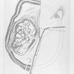
Field survey has established a detailed sequence of enclosure on the hill, the construction of the timber round-houses being placed within the later phases of occupation on the summit.
The sequence of construction of the defences is both complex and imperfectly understood, but the first recognisable phase appears to have comprised a roughly oval settlement formed by an enclosure measuring about 78m from NNE to SSW by 50m transversely within a rampart which has been reduced to a thick stony bank.
The second phase is represented by little more than a length of the ditch of a small summit enclosure that has otherwise been destroyed or masked by subsequent activity. The ditch lies to the W of the summit, some way down the steep rocky slope, and its outer lip appears to cut into the inner face of earlier rampart.
In the third phase, an oval enclosure, measuring about 78m from NNE to SSW by 43m internally was constructed, with an entrance on the ESE. For most of its length, this rampart follows the line taken by the first-phase enclosure and has probably reused an existing entrance gap, but on the W it climbs up onto the line of the crest of the summit, and overlies the second phase rampart.
The successive defensive circuits on the summit fall within a larger enclosure, measuring about 143m from NNE to SSW by 114m within double banks and a medial ditch. Most of the E half of this enclosure has been destroyed by cultivation but the W half is well-preserved. Its place in the defensive sequence is unclear, but at two places on the W side, the inner bank departs from the line of the ditch and outer bank to butt on to, and thus overlie, the phase one rampart. Without excavation, however, it is impossible to determine whether this large enclosure represents an independent phase of defence or an element of one of the other fortifications.
Within the latest settlement, the stances of at least thirty-five timber round-houses can be identified; several are of ring-groove type and many have been built on platforms, but none can be assigned to any particular phase of enclosure. Several have been built across the line of the phase two defences and others have been cut into the inner face of the phase three bank.
Later occupation or use of the hill is indicated by the presence of a sub-rectangular building platform, which has been built upon a round-house stance, and a small pen, the footings of which are visible towards the S side of the interior of the largest enclosure.
Visited by RCAHMS (JRS), 13 August 1993.
Listed as fort. Overlain by building.
RCAHMS 1997.
Note (1 July 2014 - 18 October 2016)
This fort is situated on Camp Hill and comprises a complex sequence of univallate fortifications occupying the hillock forming the summit, and a much larger outer enclosure contouring around a shoulder at a lower level. The earliest of the ramparts probably enclosed an area measuring about 78m from NNE to SSW by 50m transversely (0.34ha), though its course is largely masked around the SE half of the circuit by the latest, phase 3, line, which includes an entrance on the ESE. This rampart takes in a rather smaller area of about 0.26ha, but on the W overrides yet another line of vallation (phase 2). Now fragmentary, particularly where it is overlain by house platforms within the interior, this last encloses no more than 0.1ha on the summit, but was apparently accompanied by an external ditch, which can be seen cut into the rear of the surviving sector of the phase 1 rampart at the foot of the summit hillock on the W. Within the interior the stances of no fewer than 35 round-houses can be seen, mainly comprising platforms but including several with ring-grooves. None can be assigned to a specific phase, but their construction has virtually obliterated the line of the phase 2 rampart within the interior, while several others have been cut back into the phase 3 rampart. Whether this implies a phase of post-defensive open settlement, or possibly that the larger outer enclosure was itself a free-standing line of defence, is not known. The outer enclosure, which had been virtually ploughed out on the NE and SE by the middle of the 19th century, takes in an area measuring 143m from NNE to SSW by 114m transversely (1.3ha) within twin banks with a medial ditch about 5m in breadth; The position of its entrance is unknown, a break on the SSW being relatively modern.
Information from An Atlas of Hillforts of Great Britain and Ireland – 18 October 2016. Atlas of Hillforts SC1094
Project (29 May 2014)
An archaeological evaluation was undertaken by CFA Archaeology Ltd, a desk based assessment and walk over survey (May 29th 2014) was conducted
The historic environment record within the Site Boundary is relatively limited, although there is some potential for the proposed development site to contain previously unknown heritage assets from at least the later prehistoric period onwards, given the historic landscape character of the wider area. Taking this into account, the archaeological potential of the proposed development site is considered to be low.
A summary assessment, on a site by site basis, of the predicted effects on the settings of assets within a 10km radius where the blade tip ZTV indicates that there would be theoretical views of one or more turbines
information from Héléna Gray, (CFA Archaeology Ltd), August 2015
OASIS ID: cfaarcha1-278420

