
Pricing Change
New pricing for orders of material from this site will come into place shortly. Charges for supply of digital images, digitisation on demand, prints and licensing will be altered.
King Schaws Grave, Bank Head Hill


Cairn (Early Bronze Age), Cist (Early Bronze Age), Inhumation (Early Bronze Age)
Site Name King Schaws Grave, Bank Head Hill
Classification Cairn (Early Bronze Age), Cist (Early Bronze Age), Inhumation (Early Bronze Age)
Alternative Name(s) Airswood Moss
Canmore ID 67325
Site Number NY29SE 3
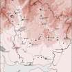
NGR NY 25939 93207
Datum OSGB36 - NGR
Permalink http://canmore.org.uk/site/67325


- Council Dumfries And Galloway
- Parish Westerkirk
- Former Region Dumfries And Galloway
- Former District Annandale And Eskdale
- Former County Dumfries-shire
NY29SE 3 2593 9320.
(NY 2593 9320) King Schaw's Grave (NAT) Tumulus (NR)
OS 6" map (1957)
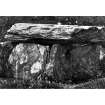
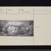
A cist, known as King Schaw's Grave and said to have contained a crouched skeleton (Name Book 1857) is situated on ground which rises slightly out of the marshy area of Airswood Moss. Oriented NE-SW, and with an end slab missing, it measures 4' x 2' x 2' 6" high.
It formerly stood within a large cairn, traces of which may still be seen. The cairn, 54' in diameter, which was demolished in 1828 to form a march dyke, consisted of loose stones, surrounded by larger ones, closely set together.
For about 14' from the inner side of the kerb, it rose gradully, but above this it changed abruptly to a steep cone, directly under which the cist was found. It contained human bones. From the four corners of the cist there extended, like a St. Andrew's Cross, rows of stones overlapping each other like the slating of a house. At the end of one of these, about 14' from the central cist, another similar cist was found, laid at right angles to the row of stones. Another is said to have been found at the end of one of the opposite limbs of the cross; and most probably all four were conjoined to cists, but much of the cairn had been removed before attention was paid to them. Between the limbs of the cross, many fragments of bones were strewn about.
RCAHMS 1920, visited 1912; D Wilson 1863; Dumfries Journal 24 June 1828
The cist is as described. The site of the cairn is delimited by long grass, and no other structures are visible. Probing revealed a stony area about 10.0m in diameter.
Revised at 1/2500.
Visited by OS (DWR) 7 October 1973
No change to previous field report.
Surveyed at 1:10,000.
Visited by OS (BS) 17 October 1978.
NY 2591 9322. Cairn; clear of planting and outer bank ploughed.
A M Jackson 1978.
(Location cited as NY 259 932). Situated on a slight eminence in fairly level moorland, now afforested, the site clearly once commanded extensive views, especially down the Esk valley, but trees now obscure visibility. The remains now comprise a low mound of stones which has been almost entirely removed, but has an identifiable diameter of 15.5m. In the centre there is a well-constructed cist of rectangular slabs orientated NW-SE and measuring 1.25m by 0.6m by 0.75m high. It is built of three slabs (the SW end being now open) and is covered by a well-fitting capstone.
On the evidence of Wilson's comprehensive description, this was clearly a complex site which contained at least two (and possibly as many as five) cists. The RCAHMS note the reported removal of 150 cartloads of stone from what was evidently a substantial monument.
M J Yates 1984.
Note (1980)
King Schaw's Grave, Bank Head Hill NY 259 932 NY29SE 3
A cist, situated in a forestry plantation, marks the site of this cairn which measured 16.5m in diameter and probably had a boulder kerb at the time of its destruction in 1828. Beneath the cairn there were 'rows of stones overlapping each other like the slating of a house', which radiated 'in the form of a St Andrew's cross' from the corners of a central cist containing a crouched inhumation; fragmentary bones were strewn about between the arms of the cross, and at the end of at least one arm there was a cist.
RCAHMS 1980
(Name Book, Dumfries, No. 53, p. 12; Wilson 1863, i, 88-9; RCAHMS 1920, p. 218, No. 648)
Note (1997)
NY29SE 3 2593 9320
Listed as cairn.
RCAHMS 1997

