|
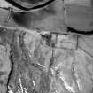
Photographs and Off-line Digital Images |
DF 2902 |
RCAHMS Aerial Photography |
Oblique aerial view. |
1980 |
Item Level |
|
|
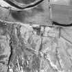
Photographs and Off-line Digital Images |
DF 2903 |
RCAHMS Aerial Photography |
Oblique aerial view. |
1980 |
Item Level |
|
 |
On-line Digital Images |
SC 381668 |
|
|
|
Item Level |
|
|
Photographs and Off-line Digital Images |
C 55904 CN |
RCAHMS Aerial Photography |
Raeburnfoot, oblique aerial view, taken from the NE, centred on the Roman Fort. Raeburnfoot farmsteading is visible in the bottom left-hand corner of the photograph and Craighaugh settlement and platform-building is shown in the top right-hand corner. |
14/2/1996 |
Item Level |
|
 |
On-line Digital Images |
SC 1761004 |
RCAHMS Aerial Photography |
Oblique aerial view. |
1980 |
Item Level |
|
 |
On-line Digital Images |
SC 1761005 |
RCAHMS Aerial Photography |
Oblique aerial view. |
1980 |
Item Level |
|
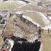 |
On-line Digital Images |
SC 1761153 |
RCAHMS Aerial Photography |
Raeburnfoot, oblique aerial view, taken from the NE, centred on the Roman Fort. Raeburnfoot farmsteading is visible in the bottom left-hand corner of the photograph and Craighaugh settlement and platform-building is shown in the top right-hand corner. |
14/2/1996 |
Item Level |
|
|
Photographs and Off-line Digital Images |
C 55903 CN |
RCAHMS Aerial Photography |
Oblique aerial view of Roman Fort, Raeburnfoot. |
14/2/1996 |
Item Level |
|
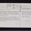 |
On-line Digital Images |
SC 2471891 |
Records of the Ordnance Survey, Southampton, Hampshire, England |
Craighaugh, NY29NW 8, Ordnance Survey index card, page number 1, Recto |
c. 1958 |
Item Level |
|
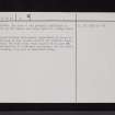 |
On-line Digital Images |
SC 2471892 |
Records of the Ordnance Survey, Southampton, Hampshire, England |
Craighaugh, NY29NW 8, Ordnance Survey index card, page number 2, Verso |
c. 1958 |
Item Level |
|
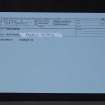 |
On-line Digital Images |
SC 2471893 |
Records of the Ordnance Survey, Southampton, Hampshire, England |
Craighaugh, NY29NW 8, Ordnance Survey index card, Recto |
c. 1958 |
Item Level |
|
|
All Other |
551 166/1/1 |
Records of the Ordnance Survey, Southampton, Hampshire, England |
Archaeological site card index ('495' cards) |
1947 |
Sub-Group Level |
|


