
Calf Knowe


Hut(S) (Post Medieval), Ring Enclosure(S) (Post Medieval)
Site Name Calf Knowe
Classification Hut(S) (Post Medieval), Ring Enclosure(S) (Post Medieval)
Alternative Name(s) Raeburnfoot
Canmore ID 67252
Site Number NY29NE 3
NGR NY 25265 99379
NGR Description Centred NY 2525 9937
Datum OSGB36 - NGR
Permalink http://canmore.org.uk/site/67252


- Council Dumfries And Galloway
- Parish Eskdalemuir
- Former Region Dumfries And Galloway
- Former District Annandale And Eskdale
- Former County Dumfries-shire
NY29NE 3 centred 2525 9937
(Centred NY 2525 9937) Hut Circles (NR)
OS 6" map (1965)
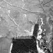
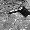
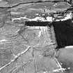
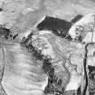
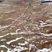
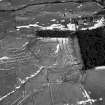
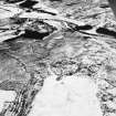
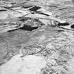
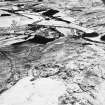
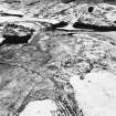
Situated around the summit of a small prominent knoll c. 200m N of Raeburnfoot is a group of five hut circles or enclosures varying in diameter from 5.0m to 7.0m, formed by turf-covered banks. No entrances were seen in any of these structures. Some 115m SE of the knoll is another oval-shaped enclosure measuring 11.0m x 6.4m formed by an earth-and-stone bank 2.1m wide by 0.4m high. Part of this bank has been obliterated at the E end.
Surveyed at 1:2500 scale.
Visited by OS (WDJ) 22 August 1962
A group of five enclosures generally as described. There is no trace of the one to the SE. They are all "sod dykes" for use as sheep pens. See also type site NY29NE 16.
Visited by OS (IA) 9 October 1973.
Measured Survey (4 June 1992)
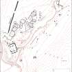
RCAHMS surveyed the ring-enclosures at Calf Knowe on 4 June 1992 with plane-table and self-reducing alidade at a scale of 1:250. The plan was redrawn in ink and published at a scale of 1:500 (RCAHMS 1997, Fig. 83).
Field Visit (June 1992)
NY29NE 3 2525 9937
Grouped on Calf Knowe (a low knoll situated in otherwise poorly-drained ground) and some 130m N of Raeburnfoot steading (NY29NE 79), there is a cluster of three ring-enclosures and a hut. All are of turf construction and the surrounding pattern of turf-cutting corresponding to each can still be traced.
Two of the ring-enclosures (on the N and WNW flanks respectively of the knoll) are of broadly similar size, measuring 4.5m and 5m in diameter respectively within banks 2.8m thick and 0.4m high. The third ring-enclosure occupies the summit of the knoll and is larger, measuring up to 6m in diameter within a bank spread to a thickness of 3m and 0.6m high; it stands on a plinth of uncut turf which extends in an apron around the perimeter of the enclosure.
End-on to this last ring-enclosure, and occupying a slightly lower position on the W side of the knoll, there are the grass-grown remains of a hut. It is subrectangular on plan with rounded external angles and measures 12.2m from ESE to WNW by 8.9m transversely over a bank spread up to 2.1m thick; the entrance is central to its SSW wall. On the ESE, it overlies the remains of what may be an earlier hut of comparable size. Both huts have external drainage-trenches.
Visited by RCAHMS (IMS, IP), June 1992.
Listed as huts.
RCAHMS 1997.

