|
Photographs and Off-line Digital Images |
D 82541 PO |
|
General view of cairn at Eskdalemuir manse. |
|
Item Level |
|
|
Prints and Drawings |
DC 32193 |
Records of the Royal Commission on the Ancient and Historical Monuments of Scotland (RCAHMS), Edinbu |
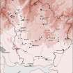
Map showing the distribution of Neolithic and Bronze Age funerary monuments (cists, round cairns, burials, ring-ditches and long cairns) in Annandale and Eskdale. Published in Eastern Dumfriesshire: an archaeological landscape. |
1996 |
Item Level |
|
|
Prints and Drawings |
DC 32757 |
Records of the Royal Commission on the Ancient and Historical Monuments of Scotland (RCAHMS), Edinbu |
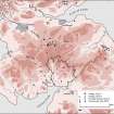
Map showing the distribution of henges and penannular ring-ditches in southern Scotland and northern England. Published in Eastern Dumfriesshire: an archaeological landscape. |
1996 |
Item Level |
|
|
Digital Files (Non-image) |
GV 007448 |
Records of the Royal Commission on the Ancient and Historical Monuments of Scotland (RCAHMS), Edinbu |
Map showing the distribution of Neolithic and Bronze Age funerary monuments (cists, round cairns, burials, ring-ditches and long cairns) in Annandale and Eskdale. Published in Eastern Dumfriesshire: an archaeological landscape. |
1996 |
Item Level |
|
 |
On-line Digital Images |
SC 1917621 |
Records of the Royal Commission on the Ancient and Historical Monuments of Scotland (RCAHMS), Edinbu |
Map showing the distribution of Neolithic and Bronze Age funerary monuments (cists, round cairns, burials, ring-ditches and long cairns) in Annandale and Eskdale. Published in Eastern Dumfriesshire: an archaeological landscape. |
1996 |
Item Level |
|
|
Digital Files (Non-image) |
GV 007452 |
Records of the Royal Commission on the Ancient and Historical Monuments of Scotland (RCAHMS), Edinbu |
Map showing the distribution of henges and penannular ring-ditches in southern Scotland and northern England. Published in Eastern Dumfriesshire: an archaeological landscape. |
1996 |
Item Level |
|
 |
On-line Digital Images |
SC 1917644 |
Records of the Royal Commission on the Ancient and Historical Monuments of Scotland (RCAHMS), Edinbu |
Map showing the distribution of henges and penannular ring-ditches in southern Scotland and northern England. Published in Eastern Dumfriesshire: an archaeological landscape.
|
1996 |
Item Level |
|
 |
On-line Digital Images |
SC 2471826 |
Records of the Ordnance Survey, Southampton, Hampshire, England |
Eskdalemuir Manse, NY29NE 26, Ordnance Survey index card, page number 1, Recto |
c. 1958 |
Item Level |
|
|
All Other |
551 166/1/1 |
Records of the Ordnance Survey, Southampton, Hampshire, England |
Archaeological site card index ('495' cards) |
1947 |
Sub-Group Level |
|


