
Eskdalemuir Manse


Burial Cairn (Early Bronze Age)
Site Name Eskdalemuir Manse
Classification Burial Cairn (Early Bronze Age)
Canmore ID 67248
Site Number NY29NE 26
NGR NY 25314 97149
Datum OSGB36 - NGR
Permalink http://canmore.org.uk/site/67248


- Council Dumfries And Galloway
- Parish Eskdalemuir
- Former Region Dumfries And Galloway
- Former District Annandale And Eskdale
- Former County Dumfries-shire
NY 2531 9715. The cairn, which has been disturbed, is as described. Surveyed at 1:2500.
Visited by OS (MJF) 26 August 1981.
Field Visit (June 1980)
Eskdalemuir Manse NY 253 971 NY29NE 26
This cairn occupies the summit of a knoll about 230m W of Eskdalemuir Manse; it measures 7.6m in diameter and 0.25m in height within a shallow penannular ditch up to 1.9m in breadth.
RCAHMS 1980, visited June 1980
Note (1997)
NY29NE 26 2531 9715
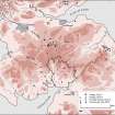
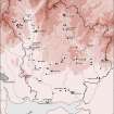
The shallow penannular ditch that surrounds this cairn is plotted as a ring-ditch on a distribution map of henge monuments and penannular ring-ditches covering southern Scotland (RCAHMS 1997, 116, fig. 111).
Information from RCAHMS (ARG) 30 September 1997.
Listed as cairn.
RCAHMS 1997

