 |
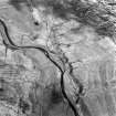
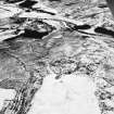
On-line Digital Images |
SC 1761010 |
RCAHMS Aerial Photography |
Oblique aerial view. |
1980 |
Item Level |
|
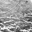 |
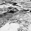
On-line Digital Images |
SC 1761129 |
RCAHMS Aerial Photography |
Raeburnfoot, oblique aerial view, taken from the NW, centred on the bank barrow. Enclosures and ring-enclosures are visible in the top left-hand corner of the photograph. |
14/2/1996 |
Item Level |
|
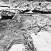 |
On-line Digital Images |
SC 1761146 |
RCAHMS Aerial Photography |
Raeburnfoot, oblique aerial view, taken from the NNE, centred on a bank barrow, with ring-enclosures, enclosures and a Roman Fort to the left of the photograph. |
22/2/1996 |
Item Level |
|
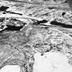 |
On-line Digital Images |
SC 1761147 |
RCAHMS Aerial Photography |
Raeburnfoot, oblique aerial view, taken from the N, centred on a bank barrow, with ring-enclosures, enclosures and a Roman Fort to the left of the photograph. |
22/2/1996 |
Item Level |
|
 |
On-line Digital Images |
SC 1761148 |
RCAHMS Aerial Photography |
Raeburnfoot, oblique aerial view, taken from the NNW, centred on a bank barrow, with ring-enclosures, enclosures and a Roman Fort to the left of the photograph. |
22/2/1996 |
Item Level |
|
 |
On-line Digital Images |
SC 1761149 |
RCAHMS Aerial Photography |
Raeburnfoot, oblique aerial view, taken from the NW, centred on a bank barrow, with ring-enclosures, enclosures and a Roman Fort to the top of the photograph. |
22/2/1996 |
Item Level |
|
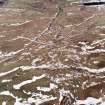 |
On-line Digital Images |
SC 1761156 |
RCAHMS Aerial Photography |
Raeburnfoot, oblique aerial view, taken from the NW, centred on the bank barrow. Enclosures and ring-enclosures are visible in the top half of the photograph. |
14/2/1996 |
Item Level |
|
|
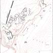
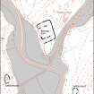
Digital Files (Non-image) |
GV 007440 |
Records of the Royal Commission on the Ancient and Historical Monuments of Scotland (RCAHMS), Edinbu |
Map of archaeological features in the landscape around Raeburnfoot. Published in Eastern Dumfriesshire: an archaeological landscape. |
1996 |
Item Level |
|
 |
On-line Digital Images |
SC 1917419 |
Records of the Royal Commission on the Ancient and Historical Monuments of Scotland (RCAHMS), Edinbu |
Map of archaeological features in the landscape around Raeburnfoot. Published in Eastern Dumfriesshire: an archaeological landscape. |
1996 |
Item Level |
|
|
Digital Files (Non-image) |
GV 007444 |
Records of the Royal Commission on the Ancient and Historical Monuments of Scotland (RCAHMS), Edinbu |
Map of archaeological features in the landscape around Raeburnfoot. Published in Eastern Dumfriesshire: an archaeological landscape. |
1996 |
Item Level |
|
 |
On-line Digital Images |
SC 1917508 |
Records of the Royal Commission on the Ancient and Historical Monuments of Scotland (RCAHMS), Edinbu |
Map of archaeological features in the landscape around Raeburnfoot. Published in Eastern Dumfriesshire: an archaeological landscape. |
1996 |
Item Level |
|
|
Photographs and Off-line Digital Images |
SC 1931944 |
Cambridge University Collection for Aerial Photography |
Oblique aerial view |
6/2/1979 |
Item Level |
|
|
Photographs and Off-line Digital Images |
SC 1931960 |
Cambridge University Collection for Aerial Photography |
|
6/2/1979 |
Item Level |
|
|
Photographs and Off-line Digital Images |
SC 1931961 |
Cambridge University Collection for Aerial Photography |
|
6/2/1979 |
Item Level |
|
|
Photographs and Off-line Digital Images |
SC 1931962 |
Cambridge University Collection for Aerial Photography |
|
6/2/1979 |
Item Level |
|
|
Photographs and Off-line Digital Images |
SC 1932018 |
Cambridge University Collection for Aerial Photography |
|
6/2/1979 |
Item Level |
|
 |
On-line Digital Images |
SC 2471804 |
Records of the Ordnance Survey, Southampton, Hampshire, England |
Rae Burn, NY29NE 16, Ordnance Survey index card, Recto |
c. 1958 |
Item Level |
|
 |
On-line Digital Images |
SC 2471805 |
Records of the Ordnance Survey, Southampton, Hampshire, England |
Rae Burn, NY29NE 16, Ordnance Survey index card, Recto |
c. 1958 |
Item Level |
|
|
All Other |
551 166/1/1 |
Records of the Ordnance Survey, Southampton, Hampshire, England |
Archaeological site card index ('495' cards) |
1947 |
Sub-Group Level |
|


