|
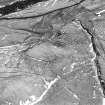
Photographs and Off-line Digital Images |
DF 2915 |
RCAHMS Aerial Photography |
Oblique aerial view. |
1980 |
Item Level |
|
|
Photographs and Off-line Digital Images |
DF 3718 PO |
Cambridge University Collection for Aerial Photography |
|
6/2/1979 |
Item Level |
|
|
Photographs and Off-line Digital Images |
DF 3719 PO |
Cambridge University Collection for Aerial Photography |
|
6/2/1979 |
Item Level |
|
|
Photographs and Off-line Digital Images |
DF 3720 PO |
Cambridge University Collection for Aerial Photography |
|
6/2/1979 |
Item Level |
|
|
Photographs and Off-line Digital Images |
DF 3815 PO |
Cambridge University Collection for Aerial Photography |
|
6/2/1979 |
Item Level |
|
|
Photographs and Off-line Digital Images |
B 51837 PO |
Cambridge University Collection for Aerial Photography |
Oblique aerial view |
6/2/1979 |
Item Level |
|
|
Photographs and Off-line Digital Images |
DF 2906 |
RCAHMS Aerial Photography |
Oblique aerial view. |
1980 |
Item Level |
|
|
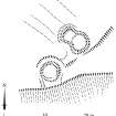
Prints and Drawings |
DC 32324 |
Records of the Royal Commission on the Ancient and Historical Monuments of Scotland (RCAHMS), Edinbu |
Survey drawing; Plan of Rae Burn ring-enclosures. |
5/6/1992 |
Item Level |
|
|
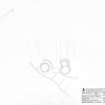
Prints and Drawings |
DC 32559 |
Records of the Royal Commission on the Ancient and Historical Monuments of Scotland (RCAHMS), Edinbu |
Publication drawing; Plan of Rae Burn ring-enclosures. |
15/3/1995 |
Item Level |
|
|
Prints and Drawings |
DC 32181 |
Records of the Royal Commission on the Ancient and Historical Monuments of Scotland (RCAHMS), Edinbu |
Map of archaeological features in the landscape around Raeburnfoot. Published in Eastern Dumfriesshire: an archaeological landscape. |
1996 |
Item Level |
|
 |
On-line Digital Images |
SC 381990 |
Records of the Royal Commission on the Ancient and Historical Monuments of Scotland (RCAHMS), Edinbu |
Publication drawing; Plan of Rae Burn ring-enclosures. |
15/3/1995 |
Item Level |
|
|
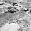
Photographs and Off-line Digital Images |
C 55687 |
RCAHMS Aerial Photography |
Raeburnfoot, oblique aerial view, taken from the NNE, centred on a bank barrow, with ring-enclosures, enclosures and a Roman Fort to the left of the photograph. |
22/2/1996 |
Item Level |
|
|
Photographs and Off-line Digital Images |
C 55688 |
RCAHMS Aerial Photography |
Raeburnfoot, oblique aerial view, taken from the N, centred on a bank barrow, with ring-enclosures, enclosures and a Roman Fort to the left of the photograph. |
22/2/1996 |
Item Level |
|
|
Photographs and Off-line Digital Images |
C 55689 |
RCAHMS Aerial Photography |
Raeburnfoot, oblique aerial view, taken from the NNW, centred on a bank barrow, with ring-enclosures, enclosures and a Roman Fort to the left of the photograph. |
22/2/1996 |
Item Level |
|
|
Photographs and Off-line Digital Images |
C 55690 |
RCAHMS Aerial Photography |
Raeburnfoot, oblique aerial view, taken from the NW, centred on a bank barrow, with ring-enclosures, enclosures and a Roman Fort to the top of the photograph. |
22/2/1996 |
Item Level |
|
|
Photographs and Off-line Digital Images |
C 55527 |
RCAHMS Aerial Photography |
Raeburnfoot, oblique aerial view, taken from the NW, centred on the bank barrow. Enclosures and ring-enclosures are visible in the top left-hand corner of the photograph. |
14/2/1996 |
Item Level |
|
|
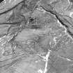
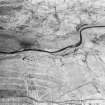
Photographs and Off-line Digital Images |
C 55518 |
RCAHMS Aerial Photography |
Raeburnfoot, oblique aerial view, taken from the N, centred on a number of ring-ditches and enclosures. The course of the Roman road is visible in the top half of the photograph. |
14/2/1996 |
Item Level |
|
|
Photographs and Off-line Digital Images |
C 55517 |
RCAHMS Aerial Photography |
Raeburnfoot, oblique aerial view, taken from the NE, centred on a number of ring-ditches and enclosures. The course of the Roman road is visible in the top left half of the photograph. |
14/2/1996 |
Item Level |
|
|
Photographs and Off-line Digital Images |
C 55907 CN |
RCAHMS Aerial Photography |
Raeburnfoot, oblique aerial view, taken from the NW, centred on the bank barrow. Enclosures and ring-enclosures are visible in the top half of the photograph. |
14/2/1996 |
Item Level |
|
 |
On-line Digital Images |
SC 842742 |
RCAHMS Aerial Photography |
Raeburnfoot, oblique aerial view, taken from the NW, centred on a bank barrow, with ring-enclosures, enclosures and a Roman Fort to the top of the photograph. |
22/2/1996 |
Item Level |
|
 |
On-line Digital Images |
SC 1346093 |
Records of the Royal Commission on the Ancient and Historical Monuments of Scotland (RCAHMS), Edinbu |
Survey drawing; Plan of Rae Burn ring-enclosures. |
5/6/1992 |
Item Level |
|
 |
On-line Digital Images |
SC 1760984 |
RCAHMS Aerial Photography |
Raeburnfoot, oblique aerial view, taken from the NE, centred on a number of ring-ditches and enclosures. The course of the Roman road is visible in the top left half of the photograph. |
14/2/1996 |
Item Level |
|
 |
On-line Digital Images |
SC 1760985 |
RCAHMS Aerial Photography |
Raeburnfoot, oblique aerial view, taken from the N, centred on a number of ring-ditches and enclosures. The course of the Roman road is visible in the top half of the photograph. |
14/2/1996 |
Item Level |
|
 |
On-line Digital Images |
SC 1761008 |
RCAHMS Aerial Photography |
Oblique aerial view. |
1980 |
Item Level |
|


