
Bankhead, Watcarrick


Burial Ground (Post Medieval), Chapel (Medieval)(Possible), Earthwork (Medieval), Grange (Medieval)
Site Name Bankhead, Watcarrick
Classification Burial Ground (Post Medieval), Chapel (Medieval)(Possible), Earthwork (Medieval), Grange (Medieval)
Alternative Name(s) Chapel Of Watcarrick; Bankhead Burial Ground
Canmore ID 67233
Site Number NY29NE 12
NGR NY 25265 96350
Datum OSGB36 - NGR
Permalink http://canmore.org.uk/site/67233


- Council Dumfries And Galloway
- Parish Eskdalemuir
- Former Region Dumfries And Galloway
- Former District Annandale And Eskdale
- Former County Dumfries-shire
NY29NE 12 25265 96350
(NY 2526 9634) Chapel (NR) (site of) Earthwork (NR)
OS 6" map (1965)
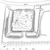
The chapel of Watcarrick, the location of which is determined by the position of the old kirkyard, served the district of Upper Eskdale till the Reformation. Vestiges of the ancient chapel, mentioned in 1592, could be seen until near the close of the 18th century, but these have since disappeared (J and R Hyslop 1912). The burial ground, enclosed by a modern wall, occupies the interior of a rectangular earthwork, c.110' by 100', whose W side has been destroyed by the modern road. The ditch is 25' broad and 6' deep below the scarp; there is a counterscarp mound, sharply defined on S and E. There has been an entrance, 7-8' wide, almost in the centre of the E side.
RCAHMS 1920, visited 1912
There is no trace of any chapel remains within the burial ground which contains stones dating to the begining of the 18th century. The earthwork is generally as described. The entrance is causewayed. Its size, shape and nature of construction indicate that it is the probable remains of a homestead moat. The relationship between the moat and the chapel cannot be determined.
Surveyed at 1/2500.
Visited by OS (WDJ) 24 August 1962 and (IA) 9 October 1973
No change to previous field report.
Visited by OS (MJF) 1 September 1978
Field Visit (9 July 1912)
Entrenchment, Old Graveyard, Bankhead,Eskdalemuir.
This entrenchment, now occupied by a burial ground with a modern wall along the scarp of its ditch, lies on the right bank of the White Esk, some 25 feet in elevation above the river, and at the south end of a hillock traversed by the road from Langholm to Eskdalemuir. In plan it is rectangular, measuring about 110 feet by 100 feet, and is surrounded by a trench some 25 feet broad and 6 feet in depth below the scarp. A mound forms the counterscarp, sharply defined on the south and east, rising some 5 feet above the bottom of the trench on the south and 3 feet on the east. On the west the defences have been destroyed by the formation of the road. Almost in the centre of the east side, facing the river, there has been an entrance, seemingly some 7 to 8 feet wide where it passes through the outer mound. This construction is marked on the O.S. map as the site of a chapel.
RCAHMS 1920, visited 9 July 1912
OS 6” map: xxvi. S.W.
Field Visit (June 1980)
Watcarrick, Chapel, Burial-ground and Earthwork NY 252 963 NY29NE 12
There are no visible remains of the chapel of Watcarrick, which is mentioned in 1305 and went out of use in 1722. The burial-ground in which the chapel stood lies within an earthwork measuring 29m square within double banks and a flat-bottomed medial ditch. The earthwork is probably of medieval date but appears to be of secular character. In the reign of David I (1124-53) the lands of Watcarrick and Tomleuchar were granted to Robert Avenel and by him to Melrose Abbey between 1153 and 1165.
RCAHMS 1980, visited June 1980
(Armstrong 1883, 147; Hyslop and Hyslop 1912, 439, 480; RCAHMS 1920, p. 79, No. 200; Cowan 1967, 208)
Field Visit (30 July 1991)
NY29NE 12 NY 2526 9634
The visible remains of this monument are as previously described. Watcarrick was a grange of Melrose abbey (NT53SW 30), and it is probable that the earthwork within which the burial-ground stands is associated with the grange.
Visited by RCAHMS (PC), 30 July 1991
Listed as moated site, chapel and burial-ground.
RCAHMS 1997.
Measured Survey (6 June 1991)
RCAHMS surveyed the earthwork and burial ground at Watcarrick at a scale of 1:500 on 6 June 1991 with plane-table and self-reducing alidade. The plan was checked on site on 16 March 1994, before being redrawn in ink in March 1995. It was published at a scale of 1:1000 as RCAHMS 1997 fig. 219.
Field Visit (1996 - 2003)
Russell Coleman managed an Historic Scotland funded project to record medieval moated sites in Scotland. Gazetteers were produced for each regional council area between 1996 and 2002 with an uncompleted overall review in 2002-03. The results of the first year of the project were published in Tayside and Fife Archaeological Journal, Volume 3 (1997).
Note (September 1997)
NY 2526 9634 NY29NE 12
This site is listed in an Atlas of Scottish History (McNeill and MacQueen 1996) as a moated site.
Information from RCAHMS (DE) September 1997.
Listed as moated site, chapel and burial ground.
RCAHMS 1997.

