Measured Survey


Date 6 June 1991
Event ID 1144844
Category Recording
Type Measured Survey
Permalink http://canmore.org.uk/event/1144844
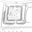
RCAHMS surveyed the earthwork and burial ground at Watcarrick at a scale of 1:500 on 6 June 1991 with plane-table and self-reducing alidade. The plan was checked on site on 16 March 1994, before being redrawn in ink in March 1995. It was published at a scale of 1:1000 as RCAHMS 1997 fig. 219.