|
Prints and Drawings |
DC 32153 |
Records of the Royal Commission on the Ancient and Historical Monuments of Scotland (RCAHMS), Edinbu |
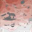
Solway Plain landscape case-study area: map showing the main medieval monuments, the extent of cultivation in about 1750, and areas of bogs and wetlands. Published in Eastern Dumfriesshire: an archaeological landscape. |
1996 |
Item Level |
|
|
Digital Files (Non-image) |
GV 007428 |
Records of the Royal Commission on the Ancient and Historical Monuments of Scotland (RCAHMS), Edinbu |
Solway Plain landscape case-study area: map showing the main medieval monuments, the extent of cultivation in about 1750, and areas of bogs and wetlands. Published in Eastern Dumfriesshire: an archaeological landscape. |
1996 |
Item Level |
|
 |
On-line Digital Images |
SC 2233915 |
Records of the Royal Commission on the Ancient and Historical Monuments of Scotland (RCAHMS), Edinbu |
Solway Plain landscape case-study area: map showing the main medieval monuments, the extent of cultivation in about 1750, and areas of bogs and wetlands. Published in Eastern Dumfriesshire: an archaeological landscape.
|
1996 |
Item Level |
|
 |
On-line Digital Images |
SC 2471291 |
Records of the Ordnance Survey, Southampton, Hampshire, England |
Westhills, NY26NE 7, Ordnance Survey index card, Recto |
c. 1958 |
Item Level |
|
 |
On-line Digital Images |
SC 2471292 |
Records of the Ordnance Survey, Southampton, Hampshire, England |
Westhills, NY26NE 7, Ordnance Survey index card, Recto |
c. 1958 |
Item Level |
|
|
All Other |
551 166/1/1 |
Records of the Ordnance Survey, Southampton, Hampshire, England |
Archaeological site card index ('495' cards) |
1947 |
Sub-Group Level |
|


