
Broomhillbank Hill


Cord Rig (Prehistoric), Fort (Prehistoric), Palisaded Enclosure (Prehistoric)
Site Name Broomhillbank Hill
Classification Cord Rig (Prehistoric), Fort (Prehistoric), Palisaded Enclosure (Prehistoric)
Alternative Name(s) Broomhill Bank Hill
Canmore ID 66971
Site Number NY19SW 7
NGR NY 12850 90860
Datum OSGB36 - NGR
Permalink http://canmore.org.uk/site/66971


- Council Dumfries And Galloway
- Parish Applegarth
- Former Region Dumfries And Galloway
- Former District Annandale And Eskdale
- Former County Dumfries-shire
NY19SW 7 12850 90860
(NY 1285 9086) Camp (NR)
OS 6" map, (1957).
Not to be confused with fort to NE (at NY 13100 91080, on the summit of the hill), for which see NY19SW 9.
Fort.
D Christison 1891; RCAHMS 1920; R W Feachem 1956
The function of the low, spread bank on the E side of this fort is problematical. It could be earlier than the defences of the small-hill-fort at the junction of the two perimeters, and is possibly a palisade mound.
G Jobey 1971
Above a steep slope on the W, but easily approached from the E, N and S, there are the remains of a two-phase settlement. The first phase consisted of a single bank and ditch which probably commenced on the steep slope on the SW to encircle an area c. 100m WNW-ESE by 110m transversely and terminated on the same slope on the NW. A shallow runnel along the top suggests that it was the retaining bank for a palisade. The second phase, slightly overlying the first at the SW corner, encloses an area c. 80m N-S by 68m transversely and survives as two grass-covered earth-and-stone banks and ditches which terminate on the S side of the entrance on the W and above the steep slope on the NW. A slight scarp continues around the top of the slope, but it is doubtful if any bank was required on this side. No internal features can now be identified.
Resurveyed at 1:2500.
Visited by OS (R D) 16 January 1972
Scheduled as 'Broomhillbank, fort 910m ENE of...'
Information from Historic Scotland, scheduling document dated 5 February 2010.
Settlement [NR]
OS (GIS) MasterMap, March 2010.
Field Visit (23 July 1912)
Fort, Broomhill Bank Hill.
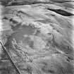
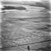
Situated on the west side of the south end of the summit of Broomhill Bank Hill, at an elevation of more than 700 feet over sea-level, is a fort commanding an extensive view of Annandale. The ground rises very steeply to the level of the fort from the east, but elsewhere from below and towards the actual summit on the north-east it mounts by easy gradients. The enceinte, which is approximately circular, measuring some 230 feet in diameter, is surrounded, except above the east declivity, by two concentric ramparts of earth and stone, the inner 18 feet wide at base and the outer 22 feet, which are separated by a trench some 18 feet wide and 4 feet in depth. Some 70 feet beyond the outer rampart lies a third of low elevation, 16 feet broad at base, which runs concentrically from the north-east, and, as it passes from south to south-west, gradually converges with the intermediate rampart, meeting it 106 feet from its termination on the south-west. At the termination of the ramparts on the south-west, a hollow, evidently the entrance, is observable passing4into the enceinte at its lowest part: beyond it the outline of what has been a slighter rampart is discernible for a few feet trending along the east face. The interior surface appears to be at its natural level and unexcavated, as also is the space within the outer and middle rampart, except towards the point of contact, where it is hollowed to a trench.
RCAHMS 1920, visited 23 July 1912.
OS 6" map, Dumf., 2nd ed, (1900).
Field Visit (18 July 1990 - 13 February 1996)
NY 1285 9086 NY19SW 7
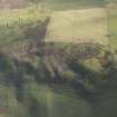
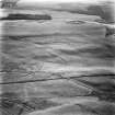
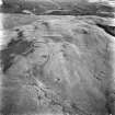
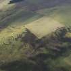
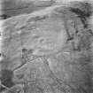
The remains of what are probably two successive palisaded enclosures and an overlying fort are situated in pasture on the SW shoulder of Broomhillbank Hill.
The palisaded enclosures are roughly concentric, the inner palisade trench being marked by little more than a shallow groove in the turf, and the outer set into the crest of a low bank; it is unclear which of the two is the earlier. Only the E arc of the inner palisade (0.5m broad and 0.1m deep) is visible lying immediately outside the defences of the later fort, but, it may have enclosed a roughly circular area measuring about 75m in diameter. The later defences have also obliterated all but the E arc of the outer enclosure, but enough survives to suggest that it enclosed an area measuring about 100m by 85m. The palisade trench is of similar dimensions to the inner, forming a groove in the crest of a grass-grown bank which measures 5m in thickness by 0.4m in height and is flanked on both sides by shallow quarry-scoops up to 2.5m broad and 0.2m deep.
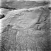
The fort is roughly oval on plan, measuring internally about 80m from NNE to SSW by 57m transversely. On the E, where the earthworks are best preserved, the defences comprise twin ramparts and ditches, but on the W ploughing has reduced the inner rampart to a scarp, and there is no evidence of the outer rampart and ditch. The two ramparts measures up to 5.3m in thickness by 0.7m in height, and the accompanying ditches up to 3.1m broad and 0.4m deep. The entrance, its N rampart terminal slightly inturned, lies on the SW, and is approached from the exterior by a trackway which becomes a hollow-way as it passes through the rampart. The interior has been cultivated and no traces of any structures are visible; amongst the later rig-and-furrow there is a patch of narrow cultivation rigs, possibly cord rig, measuring 1.3m between furrows.
Visited by RCAHMS (JRS, SMF), 18 July 1990.
There are possible traces of cord rig within the interior of the earthwork on the W shoulder of Broomhillbank Hill
Visited by RCAHMS (SPH), 13 February 1996.
Listed as fort, palisaded enclosures and cord rig.
RCAHMS 1997.
Measured Survey (1991)
RCAHMS surveyed the fort at Broomhillbank Hill (NY19SW 7) with plane-table and self-reducing alidade in 1991 at a scale of 1:500. The plan was redrawn in ink and published at a scale of 1:1000 (RCAHMS 1997, Fig. 123).
Note (18 June 2014 - 18 October 2016)
What is probably a fortified settlement displaying a complex sequence of at least three timber and earthwork perimeters is situated on gently sloping ground dropping into the lip of the steep NW flank of the SW spur of Broomhillbank Hill. The latest enclosure is oval on plan, and its interior measures about 80m from N to S by 69m transversely (0.4ha); around the E half of the circuit the perimeter comprises two low ramparts about 5m thick by 0.7m high accompanied by shallow ditches about 3m broad, but only the inner can be traced as a low scarp around the W half, and the way the two lines converge slightly towards the edge of the escarpment suggests that these too may represent more than one phase of construction. Nevertheless, there is a well-formed entrance on the SW, from which a worn hollow rises into the interior; apart from possible traces of cord rig, the interior is otherwise featureless. What are probably two earlier circuits can be seen outside the defences on the E, though in both cases degradation through later cultivation has created ambiguities in the relationships observed by field survey (see RCAHMS 1997, 127, fig 123). The inner comprises traces of a palisade trench, which seems to loop out from under the later defences for a distance of about 70m, while the outer is a low bank 5m in thickness flanked on both sides by shallow ditches 2.5m in breadth; a groove in the crest of this bank has been interpreted as possible evidence of another palisade trench. The projected circuit of this outer enclosure measures about 100m in diameter (0.78ha).
Information from An Atlas of Hillforts of Great Britain and Ireland – 18 October 2016. Atlas of Hillforts SC1020

