
Peat Hill


Settlement (Iron Age)
Site Name Peat Hill
Classification Settlement (Iron Age)
Alternative Name(s) Carthur Hill; Dryfe Water
Canmore ID 66930
Site Number NY19SE 15
NGR NY 17827 93983
Datum OSGB36 - NGR
Permalink http://canmore.org.uk/site/66930


- Council Dumfries And Galloway
- Parish Hutton And Corrie
- Former Region Dumfries And Galloway
- Former District Annandale And Eskdale
- Former County Dumfries-shire
NY19SE 15 1783 9399.
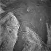
NY 1783 9399. On the gentle E slope of Peat Hill, and in a hollow above marsh is a sub-oval settlement. It measures internally about 82.0m NE-SW by 62.0m transversely between an earth and stone bank and outer ditch, best preserved in the E where there is a counterscarp. In the N on the uphill side is a 35.0m break in the bank, and on the W side of the interior a scarp probably indicates a loose platform, about 7.5m in diameter. A relatively modern field bank passes through the interior in a NNW-SSE direction.
Surveyed at 1/2500.
Visited by OS (D W R) 27 March 1972
No change to previous field report.
Surveyed at 1:10,000.
Sketch plan
Visited by OS (J R L) 22 September 1978.
Field Visit (16 May 1990)
NY 1783 9399 NY19SE 15
The remains of this settlement lie on sloping ground in the saddle between Peat Hill (to the W) and Carthur Hill (to the E), on the N side of the valley of the Dryfe Water. Roughly triangular on plan, it measures about 78m from NE to SW by up to 62m transversely within a bank (4.8m thick and up to 0.9m high internally) accompanied by an external ditch (4.8m wide and 0.6m deep), and a counterscarp bank (spread up to 2m thick and 0.5m high) can be traced around the E and the SW. The bank and ditch cannot be traced over boggy ground on the N, where the original entrance may have been situated. Elsewhere, there is a relatively recent gap in the E angle, and the ditch has been breached on the S by a modern drain.
In the interior there is a single house-platform, measuring 6.8m in internal diameter and levelled into the slope to a depth of 1m, with an entrance on the SSE. A relatively recent turf field-bank crosses the settlement from NNE to SSW.
Visited by RCAHMS (JRS, SMF), 16 May 1990.
Listed as settlement.
RCAHMS 1997.
Measured Survey (1991)
RCAHMS surveyed the settlement at Peat Hill in 1991 with plane-table and self-reducing alidade at a scale of 1:500. The plan was redrawn in ink and published at a scale of 1:1000 (RCAHMS 1997, Fig. 138).

