|
Prints and Drawings |
DC 32472 |
Records of the Royal Commission on the Ancient and Historical Monuments of Scotland (RCAHMS), Edinbu |
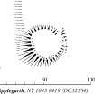
Survey drawing; Plan of Applegarthtoun (Applegarth) motte, indicating topography, modern features and specific features. |
28/3/1994 |
Item Level |
|
|
Prints and Drawings |
DC 32504 |
Records of the Royal Commission on the Ancient and Historical Monuments of Scotland (RCAHMS), Edinbu |
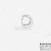
Publication drawing; Plan of Applegarth motte. |
21/2/1995 |
Item Level |
|
|
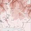
Prints and Drawings |
DC 32228 |
Records of the Royal Commission on the Ancient and Historical Monuments of Scotland (RCAHMS), Edinbu |
This map shows the distribution of timber and stone castles in Eastern Dumfriesshire and the neighbouring parts of Nithsdale and northern England. Published in Eastern Dumfriesshire: an archaeological landscape. |
1996 |
Item Level |
|
|
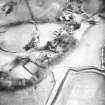
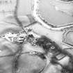
Photographs and Off-line Digital Images |
C 25425 |
RCAHMS Aerial Photography |
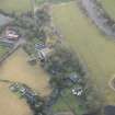
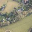
Oblique aerial view. |
1994 |
Item Level |
|
|
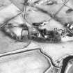
Photographs and Off-line Digital Images |
C 25426 |
RCAHMS Aerial Photography |
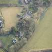
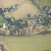
Oblique aerial view. |
1994 |
Item Level |
|
|
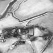
Photographs and Off-line Digital Images |
C 25427 |
RCAHMS Aerial Photography |
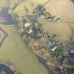
Oblique aerial view. |
1994 |
Item Level |
|
|
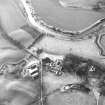
Photographs and Off-line Digital Images |
C 25428 |
RCAHMS Aerial Photography |
Oblique aerial view. |
1994 |
Item Level |
|
|
Photographs and Off-line Digital Images |
C 25429 |
RCAHMS Aerial Photography |
Oblique aerial view. |
1994 |
Item Level |
|
|
Photographs and Off-line Digital Images |
C 25430 |
RCAHMS Aerial Photography |
Oblique aerial view. |
1994 |
Item Level |
|
 |
On-line Digital Images |
SC 382023 |
Records of the Royal Commission on the Ancient and Historical Monuments of Scotland (RCAHMS), Edinbu |
Publication drawing; Plan of Applegarth motte. |
21/2/1995 |
Item Level |
|
 |
On-line Digital Images |
SC 1352991 |
Records of the Royal Commission on the Ancient and Historical Monuments of Scotland (RCAHMS), Edinbu |
Survey drawing; Plan of Applegarth motte. |
28/3/1994 |
Item Level |
|
 |
On-line Digital Images |
DP 268412 |
Historic Environment Scotland |
Oblique aerial view. |
29/1/2018 |
Item Level |
|
 |
On-line Digital Images |
DP 268413 |
Historic Environment Scotland |
Oblique aerial view. |
29/1/2018 |
Item Level |
|
 |
On-line Digital Images |
DP 268414 |
Historic Environment Scotland |
Oblique aerial view. |
29/1/2018 |
Item Level |
|
 |
On-line Digital Images |
DP 268415 |
Historic Environment Scotland |
Oblique aerial view. |
29/1/2018 |
Item Level |
|
 |
On-line Digital Images |
DP 268416 |
Historic Environment Scotland |
Oblique aerial view. |
29/1/2018 |
Item Level |
|
 |
On-line Digital Images |
SC 1670377 |
RCAHMS Aerial Photography |
Oblique aerial view. |
1994 |
Item Level |
|
 |
On-line Digital Images |
SC 1670378 |
RCAHMS Aerial Photography |
Oblique aerial view. |
1994 |
Item Level |
|
 |
On-line Digital Images |
SC 1670379 |
RCAHMS Aerial Photography |
Oblique aerial view. |
1994 |
Item Level |
|
 |
On-line Digital Images |
SC 1670380 |
RCAHMS Aerial Photography |
Oblique aerial view. |
1994 |
Item Level |
|
 |
On-line Digital Images |
SC 1670381 |
RCAHMS Aerial Photography |
Oblique aerial view. |
1994 |
Item Level |
|
 |
On-line Digital Images |
SC 1670382 |
RCAHMS Aerial Photography |
Oblique aerial view. |
1994 |
Item Level |
|
|
Digital Files (Non-image) |
GV 007464 |
Records of the Royal Commission on the Ancient and Historical Monuments of Scotland (RCAHMS), Edinbu |
Map showing the distribution of timber and stone castles in Eastern Dumfriesshire and the neighbouring parts of Nithsdale and northern England. Published in Eastern Dumfriesshire: an archaeological landscape. |
1996 |
Item Level |
|
 |
On-line Digital Images |
SC 1917782 |
Records of the Royal Commission on the Ancient and Historical Monuments of Scotland (RCAHMS), Edinbu |
Map showing the distribution of timber and stone castles in Eastern Dumfriesshire and the neighbouring parts of Nithsdale and northern England. Published in Eastern Dumfriesshire: an archaeological landscape. |
1996 |
Item Level |
|


