
Applegarth Motte


Cross (Medieval) - (Post Medieval), Motte (Medieval)
Site Name Applegarth Motte
Classification Cross (Medieval) - (Post Medieval), Motte (Medieval)
Alternative Name(s) Applegarthtoun; Applegarthtown; Applegarth Mote; Applegarth House, Motte
Canmore ID 66813
Site Number NY18SW 1
NGR NY 10433 84197
Datum OSGB36 - NGR
Permalink http://canmore.org.uk/site/66813


- Council Dumfries And Galloway
- Parish Applegarth
- Former Region Dumfries And Galloway
- Former District Annandale And Eskdale
- Former County Dumfries-shire
NY18SW 1 10433 84197
(NY 1043 8419) Mote (NR)
OS 6" map (1957).
Location formerly entered as NY 1043 8419.
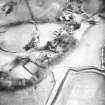
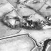
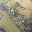
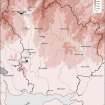
Steeply scarped on W, 29 ft. high, diminishing to 14 ft on S and E and 6ft on N. A 6ft terrace about 6ft from the summit on S and E which descends to base level on the N, appears to be original, but below it is a modern retaining wall, and it is possible that the profile has been altered in comparatively recent times. Summit 105 ft N-S, 106 ft E-W. If there was a trench on the N side there is now no trace, nor is it possible to say if a base-court ever existed.
D Christison 1891; RCAHMS 1920.
As described above.
Resurveyed at 1/2500.
Visited by OS (RD) 19 May 1966.
Scheduled as 'Applegarth House, motte 65m S of...'
Information from Historic Scotland, scheduling document dated 15 march 2010.
Motte [NAT]
OS (GIS) MasterMap, April 2010.
Field Visit (2 August 1912)
Mote, Applegarth.
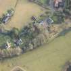
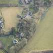
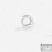
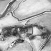
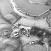
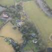
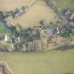
The Mote of Applegarth rises on the termination of a steep bank, which was no doubt in former days wash ed at its base on the west by the Annan, though that river now flows through meadow land more than 100 yards away. It is situated to the south of the parish church and within the grounds of the manse, the kitchen garden of which lies on its summit. From the base of the bank on the west the mound rises to a height of 29 feet with a steep scarp, the elevation diminishing as it passes round by the south to the east side to 14 feet, while to the north the height of the summit above a lawn formed on the top of the bank is only some 6 feet . In the latter direction the levels have probably been interfered with, and there is now no trace of the trench which, no doubt, existed here, nor is it possible to say whether a base-court existed on this higher level. Along the east side and round to south, some 6 feet below the summit and 8 feet above the base, is a 6-foot terrace gradually descending to the base level on the north face. This terrace on the east and south appears to be an original feature, but beneath it the mound is faced with a modern retaining wall, and it is possible that the profile has been altered in comparatively recent times. The summit of the mote is circular, measuring in diameter 105 feet from north to south by 116 feet from east to west.
RCAHMS 1920, visited 2 August 1912.
OS 6" map, Dumf., 2nd ed, (1900).
Measured Survey (28 March 1994)
RCAHMS surveyed the motte at Applegarth on 28 March 1994 with plane-table and self-reducing alidade at a scale of 1:500. The plan was redrawn in ink and published at a scale of 1:2500 (RCAHMS 1997, Fig. 202).
Reference (1997)
NY18SW 2 1043 8419
Listed as Applegarth Motte, motte and cross (lost).
RCAHMS 1997.

