|
Prints and Drawings |
DC 25001 PO |
Records of the Royal Commission on the Ancient and Historical Monuments of Scotland (RCAHMS), Edinbu |
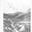
Distribution map of hut-circles in the Strath of Kildonan |
1992 |
Item Level |
|
|
Prints and Drawings |
DC 25002 PO |
Records of the Royal Commission on the Ancient and Historical Monuments of Scotland (RCAHMS), Edinbu |
Distribution map of hut-circles in the Strath of Kildonan |
1992 |
Item Level |
|
 |
Digital Files (Non-image) |
WP 003947 |
Publications by the Royal Commission on the Ancient and Historical Monuments of Scotland |
Strath Of Kildonan: an archaeological survey |
1993 |
Item Level |
|
 |
On-line Digital Images |
SC 2349847 |
Records of the Ordnance Survey, Southampton, Hampshire, England |
Kinbrace Farm, NC82NE 19, Ordnance Survey index card, page number 1, Recto |
c. 1958 |
Item Level |
|
|
All Other |
551 166/1/1 |
Records of the Ordnance Survey, Southampton, Hampshire, England |
Archaeological site card index ('495' cards) |
1947 |
Sub-Group Level |
|


