
Maggiemaut's Knowe


Earthwork (Period Unassigned)
Site Name Maggiemaut's Knowe
Classification Earthwork (Period Unassigned)
Alternative Name(s) Maggiemant; Maggiemont
Canmore ID 66420
Site Number NY09SW 6
NGR NY 0454 9140
Datum OSGB36 - NGR
Permalink http://canmore.org.uk/site/66420


- Council Dumfries And Galloway
- Parish Kirkmichael (Nithsdale)
- Former Region Dumfries And Galloway
- Former District Nithsdale
- Former County Dumfries-shire
NY09SW 6 0454 9140
(NY 0465 9148) Maggiemaut's Knowe (NAT).
OS 6" map, 1972
A scarped, ditched and walled hillock with the outline of a rectangular building visible on its flattish top. 'The site may represent a hitherto unidentified knight's fee known to be somewhere in the district.' Maggiemant.
(Visible on air photograph RAF 541/A/524 13/5/50 F20 4285-6).
A E Truckell 1959.
Maggiemont.
Third Stat Account (A E Truckell) 1962
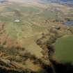
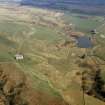
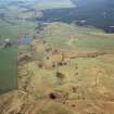
NY 0454 9140. Situated on a steep-sided hillock are the remains of an earthwork measuring internally 60.5m N-S by 32.5m E-W. It is defined by a scarp, crowned by a terrace, 02.5m wide, except on the S, where there are the apparent remains of a robbed stone wall. At the foot of the scarp on the N is a small stretch of ditch. No certain entrance is visible. In the SE a break in the scarp leads to a hollow area which may have resulted from quarrying. The interior is featureless. There is no evidence to support a medieval date for this site, but the situation is ideal for a IA fort. However, the fragmentary remains preclude positive identification, and are perhaps more suggestive of an unfinished work. Surveyed at 1:2500.
Sketch plan
Visited by OS (D W R) 19 October 1972
Maggiemaut's Knowe (name confirmed) (Mr Grant , Burrance, Dumfries) is as described in the previous field report.
Surveyed at 1:10 000.
Visited by OS (T R G) 30 August 1977.
Note (28 May 2014 - 23 May 2016)
What may be the remains of a fort are situated on a steep-sided hillock known as Maggiemaut’s Knowe, rising up on the SE side of a stream gully which opens out into an area of boggy ground that has been utilised previously as a pond. Oval on plan, the interior measures about 60m from N to S by 32m transversely (0.16ha). The rampart is best preserved in the NW quarter, forming a terrace about 2.5m in breadth with its leading edge dropping into an external ditch. The terrace can also been traced around the E flank of the hillock, but on S there is little more than a robber trench to mark its course. The position of the entrance is not known, and while the late Alfred Truckell of Dumfries Museum suggested that this might be the remains of a minor medieval caput (Truckell 1959), in 1972 the OS surveyor suggested that it is more likely to have been a fort, though in the light of its fragmentary remains he suggested that the defences were unfinished.
Information from An Atlas of Hillforts of Great Britain and Ireland – 23 May 2016. Atlas of Hillforts SC0888

