Stidriggs
Building (Post Medieval), Scooped Settlement (Iron Age)
Site Name Stidriggs
Classification Building (Post Medieval), Scooped Settlement (Iron Age)
Alternative Name(s) Willie Wilkin's Craig
Canmore ID 66360
Site Number NY09NE 24
NGR NY 0592 9893
Datum OSGB36 - NGR
Permalink http://canmore.org.uk/site/66360
- Council Dumfries And Galloway
- Parish Kirkpatrick-juxta
- Former Region Dumfries And Galloway
- Former District Annandale And Eskdale
- Former County Dumfries-shire
Measured Survey (17 August 1990)
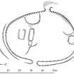
RCAHMS surveyed the scooped settlement at Stidriggs on 17 August 1990 with plane-table and self-reducing alidade at a scale of 1:500. The plan was redrawn in ink and published at a scale of 1:1000 (RCAHMS 1997, Fig. 61).
Field Visit (21 June 1990)
NY 0592 9893 NY09NE 24
This scooped settlement (which was formerly classified as an enclosure or possible settlement) was identified as an enclosure on aerial photographs (RCAHMSAP 1986) and is situated on a poorly-drained terrace above Willie Wilkin's Craig. Oval on plan, it measures about 60m from N to S by 43m transversely within a wall which has been reduced to a grass-covered bank up to 4m thick and 0.2m high. The wall has been extensively robbed on the W, leaving a well-defined robber-trench on the line of the outer face. On the E, the bank has been damaged by modern drainage ditches and obscured by the build-up of peat. The position of the original entrance is probably marked by a break in the bank on the E, where it would have been best-placed to drain the 'yard' area of the settlement. A well-defined break in the bank on the W is unlikely to be original, and it may be associated with the later structures within the enclosure.
The interior has been levelled into the natural slope on the W and contains three features which probably belong to the scooped settlement phase. On the N, abutting the inner edge of the settlement bank, there are the remains of a small hut-circle measuring about 5.5m in diameter within a low and grass-grown bank. Adjacent to it, on the W, there is a low platform which may mark the position of another round-house, and there is also a large house-platform (12.5m by 8.4m) abutting the backscarp of the settlement immediately to the S of the W entrance.
Situated close to the centre of the settlement, there are the poorly-preserved remains of a later building with what may be a small enclosure to the S. The building measures about 12m from E to W by 5m transversely over low rubble footings, and there is a small outshot at the E end.
Visited by RCAHMS (SMF, JRS), 21 June 1990.
Listed as settlement.
RCAHMS 1997.


