
Pricing Change
New pricing for orders of material from this site will come into place shortly. Charges for supply of digital images, digitisation on demand, prints and licensing will be altered.
Trailflat


Temporary Camp (Roman)
Site Name Trailflat
Classification Temporary Camp (Roman)
Canmore ID 66245
Site Number NY08NW 11
NGR NY 04898 85015
NGR Description Centred NY 0488 8501
Datum OSGB36 - NGR
Permalink http://canmore.org.uk/site/66245


- Council Dumfries And Galloway
- Parish Tinwald
- Former Region Dumfries And Galloway
- Former District Nithsdale
- Former County Dumfries-shire
NY08NW 11 centred 04898 85015
See also NY08NW 24.
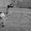
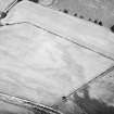
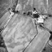
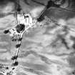
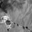
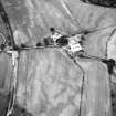
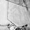
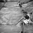
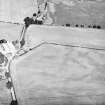
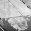
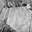
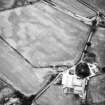
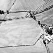
A small marching-camp measuring c. 110m by at least 120m has been located on the Water of Ae, partly underlying Trailflat farm. (Information from G S Maxwell).
S S Frere 1984
A small camp was recorded in 1983 by RCAHMS at the farm of Trailflat on the Water of Ae beside the presumed line of the Roman road leading W from Annandale towards Dalswinton. The whole of the SE side about 110m long, including a central entrance, a short stretch of the NE, and about 20m of the W side were revealed, together with the E and S angles; the area enclosed seems unlikely to exceed 1.6 ha (3.9 acres).
G S Maxwell and D R Wilson 1987.
Publication Account (17 December 2011)
The camp at Trailflat was recorded in 1983 by RCAHMS from the air, on level ground above the Water of Ae, about 1.8km ESE of the fortlet at Murder Loch, close to the presumed line of the Roman road from Annandale to Nithsdale. The whole of the south-east side, some 120m, has been recorded through cropmarks, together with up to 123m of the adjacent sides; the north-west side has not been recorded but probably lies under the farm buildings. The camp enclosed at least 1.4ha (3.5 acres) and probably not much more. An entrance gap is visible in the centre of the south-east side.
R H Jones.
Aerial Photographic Transcription (17 July 2012)

