
Pricing Change
New pricing for orders of material from this site will come into place shortly. Charges for supply of digital images, digitisation on demand, prints and licensing will be altered.
Fourmerkland


Ring Ditch (Period Unassigned)
Site Name Fourmerkland
Classification Ring Ditch (Period Unassigned)
Alternative Name(s) Burnside Of Baltersan
Canmore ID 65955
Site Number NX98SW 66
NGR NX 91533 80024
Datum OSGB36 - NGR
Permalink http://canmore.org.uk/site/65955


- Council Dumfries And Galloway
- Parish Holywood
- Former Region Dumfries And Galloway
- Former District Nithsdale
- Former County Dumfries-shire
NX98SW 66 91530 80027
See also NX98SW 5 and NX98SW 67.
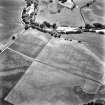
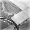
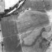
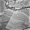
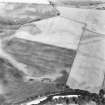
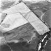
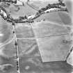
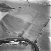
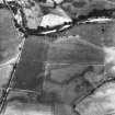
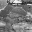
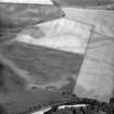
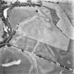
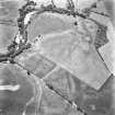
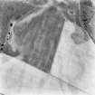
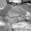
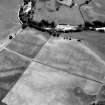
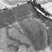
A ring-ditch is visible as cropmarks within the Roman Temporary Camp (NX98SW5).
(Undated) information in NMRS.
Scheduled (with NX98SW 5 and NX98SW 67 ) as Burnside of Baltersan, ring ditch, pits and Roman camp.
Information from Historic Scotland, scheduling document dated 11 May 1993.
This ring-ditch straddles the S side of the possible cursus monument NX98SW 67. It lies adjacent to the W terminal of the cursus and measures about 10m in internal diameter.
Information from RCAHMS (ARG), 22 April 1998
Aerial Photographic Transcription (3 May 2012)

