
Highland, Sutherland, Uppat Wood, Dunrobin Wood


Settlement (Period Unassigned)
Site Name Highland, Sutherland, Uppat Wood, Dunrobin Wood
Classification Settlement (Period Unassigned)
Canmore ID 6555
Site Number NC80SE 5
NGR NC 8721 0182
NGR Description NC 8721 0182 and Centred NC 87218 01811
Datum OSGB36 - NGR
Permalink http://canmore.org.uk/site/6555


- Council Highland
- Parish Golspie
- Former Region Highland
- Former District Sutherland
- Former County Sutherland
NC80SE 5 8721 0182
(NC 8721 0182) Enclosure (NR)
OS 6" map, (1964)
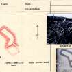
In Uppat Wood there is a "hut enclosure" of dry-stone masonry. It is oblong in form measuring some 54ft WNW-ESE by 15ft, with walls of massive stones, 7ft to 8ft thick and about 3ft high, which are lined internally with thin smooth slabs set on end. The entrance is from the ESE through a passage 14ft long. At the SE end of the oblong structure is a curved annexe 19ft in diameter with a SE entrance.
RCAHMS 1911, visited 1909.
A galleried structure, not unlike a 'wag',
Surveyed at 1:2500.
Visited by OS (E G C) 7 April 1962.
Situated on fairly level ground amidst young birch and conifers is a wag-type homestead generally as described by the RCAHMS though details are obscured by bracken and decaying tree roots.
The walls of the oblong structure are massive, 1.0m high and faced internally with unusually large stones coursed and on edge, in contrast to the circular annexe whose walls are low and denuded; the latter resembles a hut circle of simple form. The interior of the oblong contains a quantity of large tumbled stone (similar in size to the facing slabs) of which three, if in situ, resemble the stalls of a wag-like structure.
Though similar in some respects to other homesteads in the area (NC80SE 25 and NC91SW 32) it differs in that the circular annexe is subsidiary to the oblong structure rather than the reverse.
Revised at 1/10,000.
Visited by OS (J M) 21 August 1975.
NC 87218 01811 (centre) A desk-based assessment and walkover survey were undertaken in July and August 2005 in advance of the construction of a telecom mast. One previously unknown site was recorded; partly upstanding in the proposed compound, this feature survived as a partially eroded and collapsed sub-rectangular stony bank, c 25m long. Due to the large size of stone and the local archaeological context, it may be prehistoric, though a post-medieval date is also possible.
Report lodged with Highland SMR.
Sponsor: Walker Fraser Steele.
S Buchanan 2005.
Measured Survey (7 April 1962)
A galleried structure, not unlike a 'wag',
Surveyed at 1:2500.
Visited by OS (E G C) 7 April 1962.
Field Visit (21 August 1975)
Situated on fairly level ground amidst young birch and conifers is a wag-type homestead generally as described by the RCAHMS though details are obscured by bracken and decaying tree roots.
The walls of the oblong structure are massive, 1.0m high and faced internally with unusually large stones coursed and on edge, in contrast to the circular annexe whose walls are low and denuded; the latter resembles a hut circle of simple form. The interior of the oblong contains a quantity of large tumbled stone (similar in size to the facing slabs) of which three, if in situ, resemble the stalls of a wag-like structure.
Though similar in some respects to other homesteads in the area (NC80SE 25 and NC91SW 32) it differs in that the circular annexe is subsidiary to the oblong structure rather than the reverse.
Revised at 1/10,000.
Visited by OS (J M) 21 August 1975.
Desk Based Assessment (July 2005 - August 2005)
NC 87218 01811 (centre) A desk-based assessment and walkover survey were undertaken in July and August 2005 in advance of the construction of a telecom mast. One previously unknown site was recorded; partly upstanding in the proposed compound, this feature survived as a partially eroded and collapsed sub-rectangular stony bank, c 25m long. Due to the large size of stone and the local archaeological context, it may be prehistoric, though a post-medieval date is also possible.
Report lodged with Highland SMR.
Sponsor: Walker Fraser Steele.
S Buchanan 2005
Field Visit (July 2005 - August 2005)
NC 87218 01811 (centre) A desk-based assessment and walkover survey were undertaken in July and August 2005 in advance of the construction of a telecom mast. One previously unknown site was recorded; partly upstanding in the proposed compound, this feature survived as a partially eroded and collapsed sub-rectangular stony bank, c 25m long. Due to the large size of stone and the local archaeological context, it may be prehistoric, though a post-medieval date is also possible.
Report lodged with Highland SMR.
Sponsor: Walker Fraser Steele.
S Buchanan 2005

