
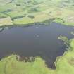
Lochrutton Loch


Crannog (Period Unassigned), Trough(S) (Wood)(Period Unassigned)(Possible)
Site Name Lochrutton Loch
Classification Crannog (Period Unassigned), Trough(S) (Wood)(Period Unassigned)(Possible)
Canmore ID 65031
Site Number NX87SE 3
NGR NX 8983 7299
Datum OSGB36 - NGR
Permalink http://canmore.org.uk/site/65031


- Council Dumfries And Galloway
- Parish Lochrutton
- Former Region Dumfries And Galloway
- Former District Stewartry
- Former County Kirkcudbrightshire
NX87SE 3 8983 7299.
(NX 8983 7299) Lake Dwelling (NR)
OS 6" map (1957)
This crannog is situated in the centre of Lochrutton Loch. It was excavated in 1901 and 1902, when it was found to consist of a circular cairn of earth 80' in diameter which rested on a foundation of logs. The wooden floor of the crannog lay beneath this earthen cap, the latter representing natural and artificial accumulations over centuries. A few signs of the post structure of the crannog house were revealed, together with parts of the verandah. All finds were of medieval type and included a jet cross with IHS monogram, the script and style fitting a mid-13th. century date. Nothing from the crannog, other than stray objects left by fishermen, need date from much after 1300. The excavation report states that they all come from levels above the log floor, and there is little reason to doubt that the crannog is most probably of Early Iron Age date. The finds from the excavation are in Dumfries Museum.
J Barbour 1906; Trans Dumfriesshire Galloway Natur Hist Antiq Soc 1906; R W Feachem 1963; A E Truckell 1964; A E Truckell and J Williams 1967.
This crannog now consists of a near-circular stone platform 24.0m-26.0m in diameter with occasional timbers visible. No vertical posts or structural features were seen.
Revised at 25"
Visited by OS (DWR) 19 November 1973
Ox teeth in Dumfries Museum (1971/126)
A E Truckell 1972
Listed among a number of crannogs examined, and from which timber samples were taken on behalf of, and funded by SDD (HBM).
T N Dixon 1989.
As the underwater component of Phase 2 of the South West Crannog Survey, the state of preservation of 14 crannog sites was evaluated in 12 lochs throughout Dumfries and Galloway as part of the Scottish Wetland Archaeology Programme (SWAP).
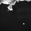
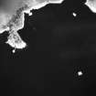
NX 8983 7299 Lochrutton Loch (NX87SE 3). The site sits in the middle of Lochrutton Loch and consists of a tree-covered island some 24m in diameter. Underwater the island expands to a mound 40m in diameter at a depth of 3m. The mound consists of small boulders (0.3-0.4m across on average), horizontal timbers (visible under stones on sides of the site in various places) and vertical piles. The latter are found mainly in concentrations around the site margins where the mound meets silt bed, but some were also detected within the mound itself. Several of the structural oak piles are over 0.4m in diameter. Alder piles were also recognised but there was no indication of other species present. Timbers were especially abundant on the S and E sides of the mound. Here a mortised timber was seen with three holes cut along one edge with fragmentary remains of the cross-piece in one of the holes. Along the E side of the site where the mound meets the loch bed, two parallel oak timbers, c 2.5m long and 0.3m wide, were seen which appeared to have been hollowed on the insides. A hole c 30 mm wide had been bored through the narrower end of one of the timbers. These timbers may represent the remains of wooden troughs.
An island 110m to the W of the crannog and marked on the 1:10,000 map as Dutton's Cairn was inspected. It was found to be entirely natural (a combination of boulders and gravel) and seems most likely to be of glacial origin.
Sponsors: HS, Scottish Trust for Archaeological Research, AOC Archaeology Group, University of Nottingham
M G Cavers and J C Henderson 2002.
Lochrutton Loch (Urr catchment): location cited as NX 8983 7299.
The upper levels of this crannog were excavated in 1901 and 19032, when it was found to comprise a circular mound of earth resting on a foundation of logs; all the finds were of medieval type. The site was dived in 1989, and two piles sampled for radiocarbon dating, which confirmed its medieval dating. Results of 820 +/- 50 bp [1130 ad] (GU-2639) and 830 +/- 50 bp [1120 ad] (GU-2640) were obtained
The remains of this mound were surveyed in July 2002 during the 2nd phase of the South-West Scotland Crannog Survey, with the intention of establishing an effective system of monitoring the rate of organic decay. As the organic remains are apparently well protected, it was not recommended for continued monitoring.
Situated in the middle of the loch, this monument comprises a tree-covered island measuring some 24m in diameter. Underwater, it expands to a diameter of about 40m at a depth of 3m. The mound comprises small boulders (typically measuring between 0.3 and 0.4m in diameter), horizontal timbers (visible in places in the sides of the mound), and vertical piles. The latter are of oak and measure over 0.4m in diameter in some cases. These were mainly found in concentrations around the edges (where the mound material rests on the silt bed) but some were identified within the mound itself. Alder piles were also recognised, but there was no indication of other species.
Timbers were especially abundant around the S and E margins. A mortised timber was seen with three holes cut along one edge, and with the fragmentary remains of a cross-piece in one of them. Along the E side of the mound, on the loch bed, there were noted two parallel oak timbers (each measuring about 2.5m long and 0.3m broad) which had apparently been hollowed internally. These may represent the remains of troughs; a hole (measuring about 30mm in diameter) had been bored through the narrower end of one of them.
This crannog is relatively well protected by deep deposits of silt. The growth of algae is apparent on exposed timbers, but there is no evidence of major organic degradation. Although visibility in the loch was noted as around 0.5-0.7m, this was due to silt in suspension. Freshwater oysters were living all over the mound, suggesting that the water is of good quality, notwithstanding local reports of slurry-dumping.
J C Henderson, B A Crone and M G Cavers 2003.

