|
Manuscripts |
MS 863/1 |
Historic Scotland Archive Project |
Report on a survey of crannogs in the south-west of Scotland (and excavations at Buiston) - Crannogs; A Diminishing Resource? |
1993 |
Item Level |
|
|
Manuscripts |
MS 1670 |
Historic Scotland Archive Project |
Report: South-West Crannog Survey: Phase 2. Field Assessment and Evaluation of Selected Crannogs. |
10/2002 |
Item Level |
|
|
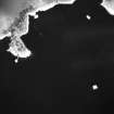
Photographs and Off-line Digital Images |
D 60878 |
RCAHMS Aerial Photography |
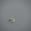
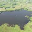
Oblique aerial view centred on the remains of the crannog, taken from the ESE. |
28/3/2000 |
Item Level |
|
|
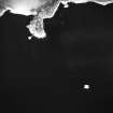
Photographs and Off-line Digital Images |
D 60879 |
RCAHMS Aerial Photography |
Oblique aerial view centred on the remains of the crannog, taken from the E. |
28/3/2000 |
Item Level |
|
|
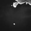
Photographs and Off-line Digital Images |
D 60880 |
RCAHMS Aerial Photography |
Oblique aerial view centred on the remains of the crannog, taken from the W. |
28/3/2000 |
Item Level |
|
|
Photographs and Off-line Digital Images |
D 60881 |
RCAHMS Aerial Photography |
Oblique aerial view centred on the remains of the crannog, taken from the WSW. |
28/3/2000 |
Item Level |
|
|
Photographs and Off-line Digital Images |
D 60882 |
RCAHMS Aerial Photography |
Oblique aerial view centred on the remains of the crannog, taken from the SW. |
28/3/2000 |
Item Level |
|
|
Photographs and Off-line Digital Images |
H 87715 CS |
RCAHMS Aerial Photography |
Oblique aerial view centred on the remains of the crannog, taken from the WSW. |
22/7/1993 |
Item Level |
|
 |
On-line Digital Images |
DP 241573 |
Historic Environment Scotland |
Oblique aerial view. |
15/8/2016 |
Item Level |
|
 |
On-line Digital Images |
DP 241682 |
Historic Environment Scotland |
Oblique aerial view. |
15/8/2016 |
Item Level |
|
 |
On-line Digital Images |
SC 1757245 |
RCAHMS Aerial Photography |
Oblique aerial view centred on the remains of the crannog, taken from the ESE. |
28/3/2000 |
Item Level |
|
 |
On-line Digital Images |
SC 1757246 |
RCAHMS Aerial Photography |
Oblique aerial view centred on the remains of the crannog, taken from the E. |
28/3/2000 |
Item Level |
|
 |
On-line Digital Images |
SC 1757247 |
RCAHMS Aerial Photography |
Oblique aerial view centred on the remains of the crannog, taken from the W. |
28/3/2000 |
Item Level |
|
 |
On-line Digital Images |
SC 1757248 |
RCAHMS Aerial Photography |
Oblique aerial view centred on the remains of the crannog, taken from the WSW. |
28/3/2000 |
Item Level |
|
 |
On-line Digital Images |
SC 1757249 |
RCAHMS Aerial Photography |
Oblique aerial view centred on the remains of the crannog, taken from the SW. |
28/3/2000 |
Item Level |
|
 |
On-line Digital Images |
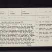
SC 2467731 |
Records of the Ordnance Survey, Southampton, Hampshire, England |
Lochrutton Loch, NX87SE 3, Ordnance Survey index card, Recto |
1958 |
Item Level |
|
 |
On-line Digital Images |
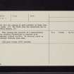
SC 2467732 |
Records of the Ordnance Survey, Southampton, Hampshire, England |
Lochrutton Loch, NX87SE 3, Ordnance Survey index card, page number 1, Recto |
1958 |
Item Level |
|
 |
On-line Digital Images |
SC 2467733 |
Records of the Ordnance Survey, Southampton, Hampshire, England |
Lochrutton Loch, NX87SE 3, Ordnance Survey index card, page number 2, Verso |
1958 |
Item Level |
|
 |
On-line Digital Images |
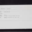
SC 2467734 |
Records of the Ordnance Survey, Southampton, Hampshire, England |
Lochrutton Loch, NX87SE 3, Ordnance Survey index card, Recto |
1958 |
Item Level |
|
|
All Other |
551 166/1/1 |
Records of the Ordnance Survey, Southampton, Hampshire, England |
Archaeological site card index ('495' cards) |
1947 |
Sub-Group Level |
|


