
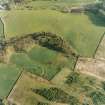
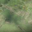
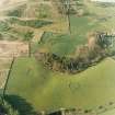
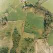
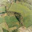
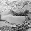
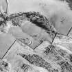
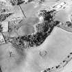
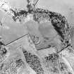
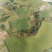
Mcnaughton's Fort


Settlement (Period Unassigned)
Site Name Mcnaughton's Fort
Classification Settlement (Period Unassigned)
Alternative Name(s) Oakwood
Canmore ID 65010
Site Number NX87NE 3
NGR NX 8735 7786
Datum OSGB36 - NGR
Permalink http://canmore.org.uk/site/65010


- Council Dumfries And Galloway
- Parish Kirkpatrick Irongray
- Former Region Dumfries And Galloway
- Former District Nithsdale
- Former County Kirkcudbrightshire
NX87NE 3 8735 7786
(NX 8735 7786) Earthwork (NR)
OS 6" map (1957)
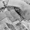
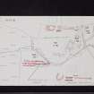
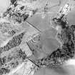
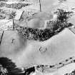
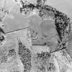
'McNaughton's Fort' was excavated in 1965, and found to consist of a rampart with outer ditch enclosing an area about 60' in internal diameter. The rampart was composed of large boulders intermixed with material excavated from the ditch, and it was supported on its inner face by a stone revetment surviving to a height of three courses. Immediately behind the revetment was a palisade trench 2' wide and 3'3" deep which it was assumed supported a continuous series of close-set timbers, rather than posts. Radio-carbon determination of the palisade timbers produced a date 280 + 100 B C. The outer edge of the rampart was defined by a single course of rounded boulders, possibly the surviving course of an outer revetment. The outer ditch had been dug 3' into the till.
The entrance consisted of a paved causeway 19' 6" wide between the rounded ends of the ditch, and the ends of the rampart flanking the entrance were revetted by timbers set in a small palisade trench 6'6" long and 2'3" deep. The main palisade trench extended some 4' beyond the ends of the rampart to provide an entrance gap 4' wide.
About a third of the interior was stripped and a number of post-holes 7"-11" in diameter and cut 6"-11" into the subsoil were located, but they formed no recognisable pattern. Further slight hollows could have been stone- holes or ploughed-out post-holes. In the SW corner of the excavated area was a palisade trench or drain 12" wide and 6"-8" deep. The only other feature was a hearth containing a deposit of ash, a small quantity of animal bones, and a whetstone. Other finds included four stone rubbers and a flint knife.
There is also an imprecise reference to the discovery in the ditch of a number of bronze (?) spearheads with gold binding on the sockets, arrowheads and other worked flints. (F R Coles 1893)
The excavators concluded that despite the fact that no certain structural form could be deduced from the plan of the post-holes recovered, the substantial nature of the palisade built against the inner face of the rampart might indicate that the whole area enclosed by the palisade formed a single building. The bank would then merely serve to support the palisade which took the main thrust of the roof, with smaller internal timbers. Analogies with West Harling and Ballacagen A, Isle of Man, are given.
Ritchie lists the site under palisaded homesteads.
J Scott-Elliot, D D A Simpson and J M Coles 1966; A Ritchie 1970
The homestead is as described and planned. No information was gained about the finds. The name was not confirmed.
Resurveyed at 1:2500.
Visited by OS (DWR) 19 November 1973
McNaughton's Fort (L Symondson, Barnsoul, Shawhead) is as described in the previous information.
Surveyed at 1:2500.
Visited by OS (TRG) 30 May 1977.
Field Visit (18 May 1951)
This site was included within the RCAHMS Marginal Land Survey (1950-1962), an unpublished rescue project. Site descriptions, organised by county, are available to view online - see the searchable PDF in 'Digital Items'. These vary from short notes, to lengthy and full descriptions. Contemporary plane-table surveys and inked drawings, where available, can be viewed online in most cases - see 'Digital Images'. The original typecripts, notebooks and drawings can also be viewed in the RCAHMS search room.
Information from RCAHMS (GFG) 19 July 2013.

