|
Manuscripts |
MS 863/1 |
Historic Scotland Archive Project |
Report on a survey of crannogs in the south-west of Scotland (and excavations at Buiston) - Crannogs; A Diminishing Resource? |
1993 |
Item Level |
|
|
Manuscripts |
MS 736/1 |
|
Photocopy of first draft of text of 'The logboats of Scotland, with notes on related artifact types'. (Submitted 1991) |
1991 |
Item Level |
|
|
Manuscripts |
MS 736/3 |
|
Annotated photocopy of undergraduate thesis on the logboats of Scotland, presented at University College, Cardiff, by the late Miss Denny Edwards. (c. 1982). Per Prof. S McGrail and Mr R Mowat, April 1993. |
c. 1982 |
Item Level |
|
|
Manuscripts |
MS 736/5 |
|
Copy of text of Scottish logboats publication by Mr R Mowat, as re-submitted for publication (June 1996) |
1996 |
Item Level |
|
|
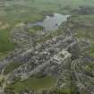
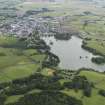
Photographs and Off-line Digital Images |
H 87723 CS |
RCAHMS Aerial Photography |
Oblique aerial view of Carlingwark Loch centred on the remains of the crannog, taken from the NE. |
22/7/1993 |
Item Level |
|
 |
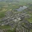
On-line Digital Images |
DP 030634 |
RCAHMS Aerial Photography Digital |
General oblique aerial view of the town with Carlingwark Loch beyond, taken from the NNW. |
27/4/2007 |
Item Level |
|
 |
On-line Digital Images |
DP 030635 |
RCAHMS Aerial Photography Digital |
General oblique aerial view of the town with Carlingwark Loch beyond, taken from the NW. |
27/4/2007 |
Item Level |
|
 |
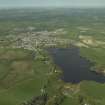
On-line Digital Images |
DP 030638 |
RCAHMS Aerial Photography Digital |
General oblique aerial view of the town with Carlingwark Loch in the foreground, taken from the SW. |
27/4/2007 |
Item Level |
|
 |
On-line Digital Images |
DP 030639 |
RCAHMS Aerial Photography Digital |
General oblique aerial view of the town with Carlingwark Loch in the foreground, taken from the SW. |
27/4/2007 |
Item Level |
|
 |
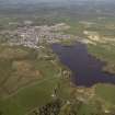
On-line Digital Images |
DP 090755 |
RCAHMS Aerial Photography Digital |
General oblique aerial view looking over Caringwark Loch towards Castle Douglas, taken from the SW. |
6/7/2010 |
Item Level |
|
 |
On-line Digital Images |
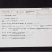
SC 2466894 |
Records of the Ordnance Survey, Southampton, Hampshire, England |
Carlingwark Loch, NX76SE 8, Ordnance Survey index card, Recto |
c. 1958 |
Item Level |
|
 |
On-line Digital Images |
SC 2466895 |
Records of the Ordnance Survey, Southampton, Hampshire, England |
Carlingwark Loch, NX76SE 8, Ordnance Survey index card, Recto |
c. 1958 |
Item Level |
|
 |
On-line Digital Images |
SC 2466896 |
Records of the Ordnance Survey, Southampton, Hampshire, England |
Carlingwark Loch, NX76SE 8, Ordnance Survey index card, Verso |
c. 1958 |
Item Level |
|
 |
On-line Digital Images |
SC 2466897 |
Records of the Ordnance Survey, Southampton, Hampshire, England |
Carlingwark Loch, NX76SE 8, Ordnance Survey index card, Recto |
c. 1958 |
Item Level |
|
|
All Other |
551 166/1/1 |
Records of the Ordnance Survey, Southampton, Hampshire, England |
Archaeological site card index ('495' cards) |
1947 |
Sub-Group Level |
|


