|
Prints and Drawings |
KBD 5/1 |
Records of the Royal Commission on the Ancient and Historical Monuments of Scotland (RCAHMS), Edinbu |
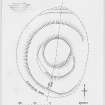
Inked plan: 'The Doon', Twynholm. |
30/9/1952 |
Item Level |
|
|
Prints and Drawings |
KBD 5/2 |
Records of the Royal Commission on the Ancient and Historical Monuments of Scotland (RCAHMS), Edinbu |
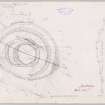
Plane-table survey: 'The Doon', Twymholm. |
30/9/1952 |
Item Level |
|
|
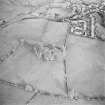
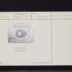
Photographs and Off-line Digital Images |
D 76510 |
RCAHMS Aerial Photography |
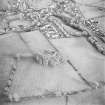
Oblique aerial view centred on the remains of the fort and rig with village adjacent, taken from the W. |
11/12/2000 |
Item Level |
|
|
Photographs and Off-line Digital Images |
D 76511 |
RCAHMS Aerial Photography |
Oblique aerial view centred on the remains of the fort and rig with village adjacent, taken from the WSW. |
11/12/2000 |
Item Level |
|
|
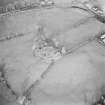
Photographs and Off-line Digital Images |
D 76512 |
RCAHMS Aerial Photography |
Oblique aerial view centred on the remains of the fort and rig, taken from the SSW. |
11/12/2000 |
Item Level |
|
|
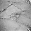
Photographs and Off-line Digital Images |
D 76513 |
RCAHMS Aerial Photography |
Oblique aerial view centred on the remains of the fort and rig, taken from the SE. |
11/12/2000 |
Item Level |
|
|
Manuscripts |
MS 36/173 |
Records of the Royal Commission on the Ancient and Historical Monuments of Scotland (RCAHMS), Edinbu |
Field notebook of K A Steer (RCAHMS). 'S6 - Kirkcudbright, Wigtown'. |
17/5/1951 |
Item Level |
|
 |
On-line Digital Images |
DP 148840 |
Records of the Royal Commission on the Ancient and Historical Monuments of Scotland (RCAHMS), Edinbu |
Inked plan: The Doon, Twynholm. |
c. 1959 |
Item Level |
|
 |
On-line Digital Images |
DP 148841 |
Records of the Royal Commission on the Ancient and Historical Monuments of Scotland (RCAHMS), Edinbu |
Plane-table survey: The Doon, Twymholm. |
30/9/1952 |
Item Level |
|
 |
Digital Files (Non-image) |
WP 000778 |
Records of the Royal Commission on the Ancient and Historical Monuments of Scotland (RCAHMS), Edinbu |
Scanned copy of RCAHMS Marginal Land Survey unpublished typescripts (Kircudbrightshire). |
1951 |
Item Level |
|
 |
On-line Digital Images |
SC 1756478 |
RCAHMS Aerial Photography |
Oblique aerial view centred on the remains of the fort and rig with village adjacent, taken from the W. |
11/12/2000 |
Item Level |
|
 |
On-line Digital Images |
SC 1756479 |
RCAHMS Aerial Photography |
Oblique aerial view centred on the remains of the fort and rig with village adjacent, taken from the WSW. |
11/12/2000 |
Item Level |
|
 |
On-line Digital Images |
SC 1756480 |
RCAHMS Aerial Photography |
Oblique aerial view centred on the remains of the fort and rig, taken from the SSW. |
11/12/2000 |
Item Level |
|
 |
On-line Digital Images |
SC 1756481 |
RCAHMS Aerial Photography |
Oblique aerial view centred on the remains of the fort and rig, taken from the SE. |
11/12/2000 |
Item Level |
|
 |
On-line Digital Images |
SC 2465685 |
Records of the Ordnance Survey, Southampton, Hampshire, England |
'The Doon', Twynholm, NX65SE 3, Ordnance Survey index card, page number 1, Recto |
c. 1958 |
Item Level |
|
 |
On-line Digital Images |
SC 2465686 |
Records of the Ordnance Survey, Southampton, Hampshire, England |
'The Doon', Twynholm, NX65SE 3, Ordnance Survey index card, page number 2, Verso |
c. 1958 |
Item Level |
|
 |
On-line Digital Images |
SC 2465687 |
Records of the Ordnance Survey, Southampton, Hampshire, England |
'The Doon', Twynholm, NX65SE 3, Ordnance Survey index card, Recto |
c. 1958 |
Item Level |
|
 |
On-line Digital Images |
SC 2465688 |
Records of the Ordnance Survey, Southampton, Hampshire, England |
'The Doon', Twynholm, NX65SE 3, Ordnance Survey index card, Recto |
c. 1958 |
Item Level |
|
|
All Other |
551 166/1/1 |
Records of the Ordnance Survey, Southampton, Hampshire, England |
Archaeological site card index ('495' cards) |
1947 |
Sub-Group Level |
|


