
Pricing Change
New pricing for orders of material from this site will come into place shortly. Charges for supply of digital images, digitisation on demand, prints and licensing will be altered.
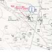
Farr


Broch (Iron Age)(Possible)
Site Name Farr
Classification Broch (Iron Age)(Possible)
Alternative Name(s) Clerkhill
Canmore ID 6404
Site Number NC76SW 1
NGR NC 7175 6338
Datum OSGB36 - NGR
Permalink http://canmore.org.uk/site/6404


- Council Highland
- Parish Farr
- Former Region Highland
- Former District Sutherland
- Former County Sutherland
NC76SW 1 7175 6338.
(NC 7175 6338) Dun (NR) (site of)
OS 6"map, (1964)
Traces of a broad stonybank on the end of a rigde. The area is roughly D-shaped and is an ideal site for a dun, although RCAHMS classify it as a broch. The house at NC 7178 6338 is called 'The Dhuine', but otherwise there is no local knowledge of the site.
J Horsburgh 1870; RCAHMS 1911, visited 1909; Visited by OS (J L D) 28 April 1960.
The remains of a broch.
Surveyed at 1:2500.
Visited by OS (R L) 7 July 1971.
The remains of a broch situated on the end of a rocky ridge. It comprises a turf-covered quarried mound, the east half of which has been removed to accommodate the outbuildings of a croft. At the base of the mound in the west arc is the base course of the broch outer face forming an arc about 9.0m long.
Visitd by OS (N K B) 8 August 1977.
Publication Account (2007)
NC76 3 CLERKHILL (‘Farr’)
NC/7175 6338
Possible broch in Farr, Sutherland, consisting of a turf-covered, quarriedmound on the end of a ridge, the east half of which has been removed tomake way for the outbuildings of a croft. On the west side is a part of the basal course of the outer wall of a broch-like structure forming an arc about 9.0m long [1].
Sources: 1. NMRS site no. NC 76 SW 1: 2. Horsburgh 1870, 275: 3. RCAHMS 1911a, 90, no. 265.
E W MacKie 2007

