
Armadale Burn


Cairnfield (Period Unassigned), Hut Circle(S) (Prehistoric)
Site Name Armadale Burn
Classification Cairnfield (Period Unassigned), Hut Circle(S) (Prehistoric)
Canmore ID 6398
Site Number NC76SE 4
NGR NC 7989 6244
Datum OSGB36 - NGR
Permalink http://canmore.org.uk/site/6398


- Council Highland
- Parish Farr
- Former Region Highland
- Former District Sutherland
- Former County Sutherland
NC76SE 4 7989 6244.
(NC 7989 6244) Enclosure (NR)
OS 6"map, (1963)
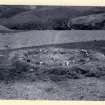
A circular enclosure found during field investigation contains a stony mound 4.0m in diameter and 0.7m high bounded by a stone kerb. Five or six small erect slabs in the NW segment of the mound suggest a cist-like structure, and other structures appear to be indicated by small stone settings within the enclosure. Its plan and dimensions suggest that this could be an enclosed cremation cemetery but it could be a hut circle, with a later field clearance heap dumped inside it. (cf NC86SW 2 and NC86SE 6).
Visited by OS (J L D) 10 May 1960.
Situated at the base of a slope on gently shelving ground is a well-preserved hut circle, measuring 10.0m WW-ESE by 9.5m transversely within a turf-covered tumbled wall surviving to 0.9m high. A number of inner facing slabs and one or two outer are visible indicating a double wall 1.9m thick, broadening to about 2.5m at the entrance in the ESE, which is 1.0m wide and clubbed. The stony mound within the hut together with the "kerb" and various "structures" appear to constitute a dump of stones large and small, rather than a deliberate construction. Many of the stones are now loose, and their arrangement witthin the hut would appear fortuitous; possibly they are cleared from the adjacent cultivation associated with a deserted croft (see NC76SE 35). The only evidence of cultivation contemporary with the hut is about six scattered clearance heaps on the dry ridges to the NW.
Revised at 1/10,000.
Visited by OS (N K B) 28 June 1977.

