
Following the launch of trove.scot in February 2025 we are now planning the retiral of some of our webservices. Canmore will be switched off on 24th June 2025. Information about the closure can be found on the HES website: Retiral of HES web services | Historic Environment Scotland
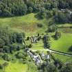
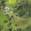
Anwoth, Old Kirk, Churchyard And Gordon Tomb


Burial Ground (17th Century), Church (17th Century), Covenanters Grave (17th Century)
Site Name Anwoth, Old Kirk, Churchyard And Gordon Tomb
Classification Burial Ground (17th Century), Church (17th Century), Covenanters Grave (17th Century)
Alternative Name(s) Anwoth Old Church, Gordon Tomb And Churchyard; Old Parish Church Of Anwoth; Anwoth, Old Kirk And Graveyard; Bell's Monument
Canmore ID 63661
Site Number NX55NE 5
NGR NX 58273 56209
Datum OSGB36 - NGR
Permalink http://canmore.org.uk/site/63661


- Council Dumfries And Galloway
- Parish Anwoth
- Former Region Dumfries And Galloway
- Former District Stewartry
- Former County Kirkcudbrightshire
Field Visit (10 July 1970)
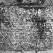
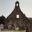
'Anwoth Old Kirk' (plaque on W gable) as described above.
Visited by OS (WDJ) 10 July 1970
Field Visit (21 February 1990)
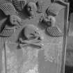
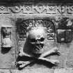
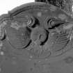
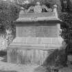
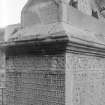
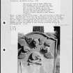
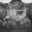
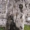
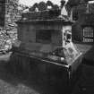
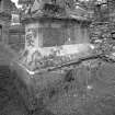
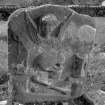
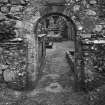
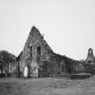
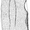
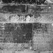
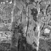
The roofless shell of this old parish church is as previously described. The elaborate Gordon Tomb and the cross-slab stand within the church. The cross-slab measures 950mm in height, 400mm in breadth and 80mm in thickness; it is not dressed and its smoother face bears the incised outline of a cross. Although the Inventory for Kirkcudbright (RCAHMS 1914) describes the cross as extending the entire length of the stone, its shaft is now only visible for 470mm below the arms, which are 280mm across.
Visited by RCAHMS (SPH) 21 February 1990.
Desk Based Assessment
NX55NE 5 58273 56209
(NX 5827 5621) Church (NR) (Remains of)
OS 6" map (1957)
For (successor and present) Parish Church (NX 58225 55951), see NX55NE 103.
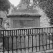
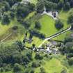
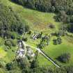
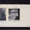
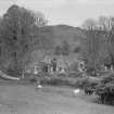
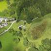
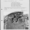
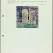
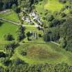
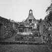
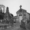
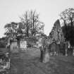
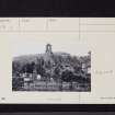
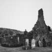
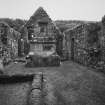
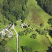
The roofless remains of the old parish church of Anwoth are oblong in plan, measuring c.70' by 18' 4" within 3' 6" thick walls, oriented W-E, with a doorway in both the W and E walls. Abutting on the S wall at the E end of the church is a comparatively modern tomb-house 13' 6" by 13'. The church was built c.1626; the date 1627 is inscribed above the door, but according to Saunders, this was recently done, being the date Samuel Rutherford became minister. It was dismantled in 1826 when the new church was built (at NX 5822 5574). Within the church is the early 17th century Gordon tomb, as illustrated, and also a cross-slab, dating to c.1100 a few yards W of the tomb, close to the N wall. It measures 2' 8" by 1' 4 1/2" and is 2 1/2" thick. It was found in the churchyard in 1892, when it was placed in its present position.
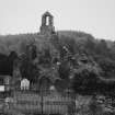
Anwoth church is first mentioned in the 12th century, when it was granted to Holyrood Abbey. In the churchyard is a monument erected to John Bell of Whiteside, a covenanter shot in 1685.
Information from OS.
RCAHMS 1914, visited 1911; F Saunders 1912; W G Collingwood 1925; A J M'culloch 1947

