
Following the launch of trove.scot in February 2025 we are now planning the retiral of some of our webservices. Canmore will be switched off on 24th June 2025. Information about the closure can be found on the HES website: Retiral of HES web services | Historic Environment Scotland
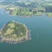
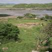
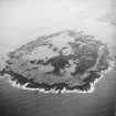
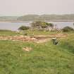
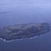
Ardwall Island, Chapel And Burial-ground


Burial Ground (5th Century) - (11th Century), Chapel (8th Century), Cross Slab(S) (Early Medieval), Hall House (Mid 13th Century) - (Mid 14th Century), Hall House (Medieval), Private Chapel (Mid 7th Century), Tower (Late 18th Century) (1780)
Site Name Ardwall Island, Chapel And Burial-ground
Classification Burial Ground (5th Century) - (11th Century), Chapel (8th Century), Cross Slab(S) (Early Medieval), Hall House (Mid 13th Century) - (Mid 14th Century), Hall House (Medieval), Private Chapel (Mid 7th Century), Tower (Late 18th Century) (1780)
Alternative Name(s) Ardwall Isle; Islands Of Fleet; Wigtown Bay; Solway Firth
Canmore ID 63626
Site Number NX54NE 6
NGR NX 57315 49575
Datum OSGB36 - NGR
Permalink http://canmore.org.uk/site/63626


- Council Dumfries And Galloway
- Parish Borgue
- Former Region Dumfries And Galloway
- Former District Stewartry
- Former County Kirkcudbrightshire
NX54NE 6 57315 49575
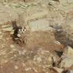
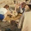
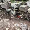
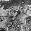
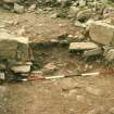
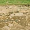
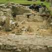
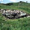
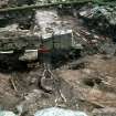
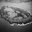
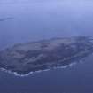
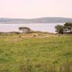
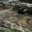
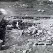
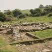
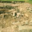
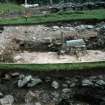
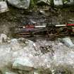
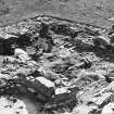
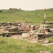
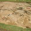
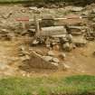
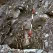
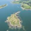
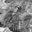
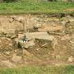
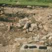
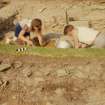
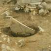
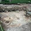
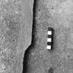
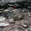
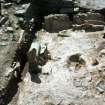
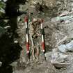
(NX 573 495) Excavations in 1964-5 on Ardwall Isle revealed a sequence of occupation starting with a local lay cemetery of possibly 5th or 6th century date to which a slab-shrine of Irish character was added c.600. A timber oratory was inserted into the cemetery in the mid-7th century, ignoring the slab-shrine, and further burials were aligned in this structure. This was in turn replaced, c.700, by a larger stone chapel, further burials being aligned on this new axis. Even when it had ceased to be used for worship and had partly collapsed, burials were inserted both inside and outside the ruins till the 11th century.
From perhaps as far back as the timber structure phase, the site was enclosed by a bank, and may have contained small cells, being probably an eremitic monastery serving the Gatehouse and Borgue district. The chapel appears to be Irish rather than Northumbrian in type.
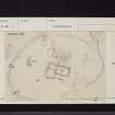
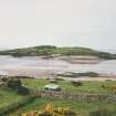
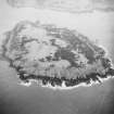
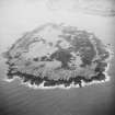
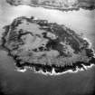
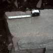
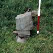
A hall-house, extant c.1250-1350, was next built on the site, and this was followed by a tower erected c.1780-1800. The main site lies on the NE edge of the island, comprising an oval area 180' ENE-WSW by 110' transversely, enclosed by a bank, much of which is now incorporated at the base of a modern sheep dyke on the E. The Early Christian entrance seems to have been a little distance S of the break where the path from the beach is, under the sheep dyke. The stone chapel lies almost exactly EW, and measures 23' by 13' within 2 3/4' wide walls.
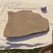
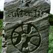
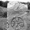
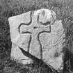
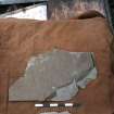
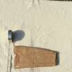
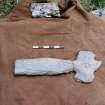
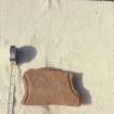
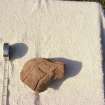
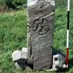
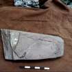
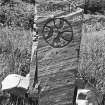
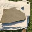
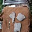
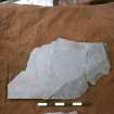
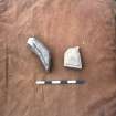
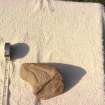
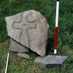
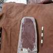
Numerous 8th/11th century cross-slabs and cross-incised stones were found during the excavation, as well as many small finds of metal, bone, glass and stone. All finds were given to Dumfries Museum.
C Thomas 1967
Field Visit (1 February 1971)
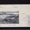
As described and planned by Thomas. His excavation has been left open and the walls of the chapel stand to an average height of c.0.4m and part of the south and east sides of the hall-house are clearly defined. The enclosing earth and stone bank is much wasted and has completely disappeared on the east side.
Surveyed at 1/2500.
Visited by OS (WDJ) 1 February 1971.
Desk Based Assessment (27 June 2000)
A single unroofed building orientated N/S which may be the 18th/19th century tavern (Thomas 1966) that overlies the earlier hall house and chapel, is depicted on the 1st edition of the OS 6-inch map (Kirkcudbrightshire 1854, sheet 49). What appears to be the excavated remains of the chapel is shown on the OS 1:10000 map (1982).
C Thomas 1966; Information from RCAHMS (AKK) 27 June 2000.

