
North Balfern


Fort (Period Unassigned)
Site Name North Balfern
Classification Fort (Period Unassigned)
Alternative Name(s) Ring Hill
Canmore ID 63414
Site Number NX45SW 4
NGR NX 4372 5095
Datum OSGB36 - NGR
Permalink http://canmore.org.uk/site/63414


- Council Dumfries And Galloway
- Parish Kirkinner
- Former Region Dumfries And Galloway
- Former District Wigtown
- Former County Wigtownshire
NX45SW 4 4372 5095.
(NX 4372 5095) Camp (NR)
OS 6" map (1957)
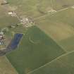
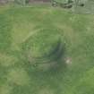
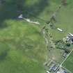
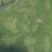
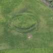
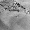
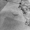
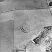
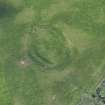
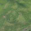
When visited in 1953, this fort (RCAHMS) or walled settlement (MoW) was seen to have deteriorated in the condition since 1911 when it was described as oval, measuring 190' WNW-ESE by 135' transversely, enclosed by a stone-walled rampart (now almost effaced, particularly on the W), crowning a steep scarp, maximum height 7'-8'. From the base of this scarp, a level terrace extends some 20' to a second scarp with a similar parapet and where these walls cross the crest of the hill, there is a suggestion of a ditch outside the outer scarp. A few pieces of vitrified and calcined material were found in 1911, particularly towards the SE edge of the central enclosure, but there were too few to suggest that the fort had been vitrified, and none were seen in 1953.
RCAHMS 1912, visited 1911; TS. 27 September 1953
A fort generally as described by RCAHMS.
Resurveyed at 1/2500.
Visited by OS (RD) 19 August 1970
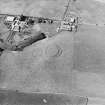
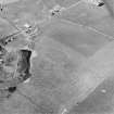
The fort is visible on vertical air photograph, (OS 66/103/177, flown 1966).
Information from RCAHMS (DE) August 1996
Field Visit (27 September 1953)
This site was included within the RCAHMS Marginal Land Survey (1950-1962), an unpublished rescue project. Site descriptions, organised by county, are available to view online - see the searchable PDF in 'Digital Items'. These vary from short notes, to lengthy and full descriptions. Contemporary plane-table surveys and inked drawings, where available, can be viewed online in most cases - see 'Digital Images'. The original typecripts, notebooks and drawings can also be viewed in the RCAHMS search room.
Information from RCAHMS (GFG) 19 July 2013.
Note (20 December 2013 - 23 May 2016)
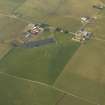
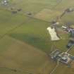
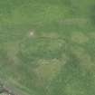
Situated on the W shoulder of a low hill, this oval fort measures about 55m from NW to SE by 35m transversely (0.14ha) within two ramparts, the outer of which is accompanied by an external ditch. Despite attrition through cultivation, the inner rampart still stands over 2m high in places, though elsewhere, particularly on the W, it has been ploughed almost flat. In 1911 RCAHMS investigators identified small fragments of vitrified stone from the inner rampart, though no trace of any vitrifaction has been seen since. The space between the two ramparts forms a level terrace some 6m broad and fronted by the outer rampart with its external ditch, thus creating a tiered effect to the present appearance of the defences which contributes to its local prominence.
Information from An Atlas of Hillforts of Great Britain and Ireland – 23 May 2016. Atlas of Hillforts SC0237

