
Following the launch of trove.scot in February 2025 we are now planning the retiral of some of our webservices. Canmore will be switched off on 24th June 2025. Information about the closure can be found on the HES website: Retiral of HES web services | Historic Environment Scotland
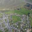
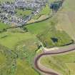
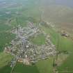
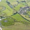
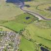
Wigtown, General


Burgh (Medieval), Village (Period Unassigned)
Site Name Wigtown, General
Classification Burgh (Medieval), Village (Period Unassigned)
Canmore ID 63362
Site Number NX45NW 37
NGR NX 43298 55306
Datum OSGB36 - NGR
Permalink http://canmore.org.uk/site/63362


- Council Dumfries And Galloway
- Parish Wigtown
- Former Region Dumfries And Galloway
- Former District Wigtown
- Former County Wigtownshire
EXTERNAL REFERENCE
Wigtown Survey report of the Royal Burgh.
The centre of the Town is described as a square enclosed by buildings with an East and West Port. The County buildings erected in 1862 dominate the houses built in 18th century county style. Windows are often embellished and doorways may have columned porticos. The condition of houses, school and public halls is criticised.
20th century GD 138/2/172

