
St Ninian's Cave


Cave (8th Century), Cross Incised Stone(S) (Early Medieval), Rock Carving(S) (Period Unassigned)
Site Name St Ninian's Cave
Classification Cave (8th Century), Cross Incised Stone(S) (Early Medieval), Rock Carving(S) (Period Unassigned)
Canmore ID 63133
Site Number NX43NW 9
NGR NX 4224 3595
Datum OSGB36 - NGR
Permalink http://canmore.org.uk/site/63133


First 100 images shown. See the Collections panel (below) for a link to all digital images.
- Council Dumfries And Galloway
- Parish Glasserton
- Former Region Dumfries And Galloway
- Former District Wigtown
- Former County Wigtownshire
St Ninian’s Cave, Wigtownshire, rock carvings
Measurements: various
Stone type:
Place of discovery: NX 4224 3595
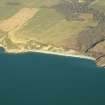
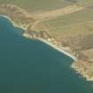
Present location: natural cleft in the cliff at the northern end of the Physgill shore on Port Castle Bay.
Evidence for discovery: the carvings were well-known locally by the mid nineteenth century. Seven incised crosses were recorded by RCAHMS in 1912, and a new survey by RCAHMS in 2004 identified another fourteen crosses.
Present condition: mostly in good condition.
Description
In its surviving form, the cave is V-shaped in plan, 10m long and a maximum of 5m wide. The crosses are incised on the south wall of the cave, all but two on the outer unroofed part. They are all of early Christian type and range from simple Latin crosses to crosses with barred terminals, ringed crosses and outline crosses, including a finely carved encircled Chi-Rho cross. A number of cross-slabs and cross-incised stones lay loose in the cave, and these are now in the Whithorn Museum except for one in the National Museum of Scotland in Edinburgh.
Date range: sixth to ninth centuries.
Primary references: RCAHMS 1912, no 3.
Desk-based information compiled by A Ritchie 2019
NX43NW 9 4224 3595
(Name: NX 4230 3597) St Ninian's Cave (NR)
OS 6" map (1957)
St Ninian's Cave is a natural cleft in the cliff face, its floor 25' OD. Excavations were carried out in it in 1884 and 1950. It was found that the occupation levels were of no great date, the earlier levels having been destroyed.
Seven early incised crosses are cut into the rock of the W wall of the cave of the cliff face outside, they are now protected by metal grills. Other cross-incised stones from the cave are in Whithorn Museum and one in the National Museum of Antiquities of Scotland (NMAS - Accession no: IB 54). The early crosses, dating to the 6th or 7th century show that it was used by Christian recluses; it must have formed the focus of some hermitage associated with Whithorn. Most of the crosses date to the 8th and 9th centuries, and the latest one, bearing part of an inscription in Anglian runes, is of 11th cent date. This was a headstone, re-used as a paving slab, which must originally have stood in or near the cave.
In 1884 a skeleton was found buried in the outer part of the cave. Possibly this burial was of a hermit, who had retired to the cave, and this cross was set up to mark his grave. Under guardianship.
NMAS 1892; RCAHMS 1912; C A R Radford and G Donaldson 1953; C A R Radford 1957; C A R Radford 1963.
NX 4224 3595 As described. No original occupation structure remains.
Visited by OS (DWR) 18 January 1973
Other material from this cave in the NMAS comprises a stone whorl, polishing stone, and part of a deerhorn handle, also two cross-incised stones.
Proc Soc Antiq Scot 1889; Proc Soc Antiq Scot 1926; Proc Soc Antiq Scot 1973.
Field Visit (14 May 1911)
St Ninian's Cave.
This cave is situated on the shore some 2 ½ m. WNW. of Burrow Head, at a point about ½ m.to the SS W. of Physgill House. The general aspect of the cliff and shore is westerly, but the cave opens to the S. in an angle formed by the projecting cliff with the shingly beach which stretches across the mouth of Physgill glen, and is situated about 25' above high-water mark. The cave is a fissure in the rocks, broadest at the mouth, and its walls slope inwards and upwards, meeting at an acute angle both at the end and the roof. Its dimensions are approximately 25' in length, 10' to 15' in height, and 8' to 10' in breadth at the mouth. Local tradition has for long associated the cave with St Ninian, whose devotional retreat it is said to have been, and the discovery of various crosses incised on the rocks and on stones found in the cave is consistent with the history assigned to it. The first discovery of Christian work in the cave was made in 1871, on the occasion of a visit of Dean Stanley, when an incised cross was observed on the rock at the W. side of the entrance (A on the plan after mentioned). A great part of the cave roof had fallen in, and in 1883 and 1884 the debris was removed under the auspices of the Ayr and Galloway Archaeological Association. The further discovery was then made of similar crosses (figs. 5 and 6) on the walls adjacent to that previously observed, and of two stones bearing incised crosses. One of these (fig. 7) shows a small equal-armed cross with the arms expanding to their terminations, set on a short' shaft and surmounted by an exactly similar cross, defective owing to a fracture of the slab: the second (fig. 8) is a coffin-shaped slab, 2' 1" in length by 9 ½' in greatest breadth: at the upper end of it is carved within a circle an equal armed cross with round hollow angles at the intersections and arms expanding to their terminations, set immediately above a cross-head of similar form incised and resting on a shaft. Both crosses have small circular depressions in the centre.
A plan (fig. 9) of the cave, which was made at the time of its exploration, is here reproduced, and referred to by letters in the following description:- Across the mouth of the cave stretched a wall (GG) of dry-stone masonry 28" thick, from which, towards one end, four steps of a stair (H) descended to the floor level of the interior, 3' below the level of the original threshold at the top of the wall. On the lowest step were incised three encircled equal-armed crosses with the arms expanding to the circumference of the circles: one has parabolic curves at the inter sections and a small incised cross in the centre; the other two have oval spaces at the inter sections and a small depression in the centre; while one rests upon a short shaft slightly concave at each side. The floor of the cave was completely paved with flags throughout its entire length except at a place (I.I.I.) where there was a space 6' X 3' to 4 ½ ' unpaved, but floored with hard-beaten earth, and in one corner (K) behind the wall, where there was an open depression for the escape of water. The pavement bore the marks of fire, and was covered with wood-ashes, bones, and shells. At L, carved on the rock 3' above the pavement, is a faintly incised cross with the arms expanding outwards, and a stem slightly longer than the upper arm. Upon a flagstone beneath it was a rudely cut inscription on which the letters SANCT / NI-P remain. Outside the wall, at a depth of 3', there was found at M a stone (fig. 10) on which was incised a circle containing an equal-armed cross with expanding arms and incised circles at the intersections, each with a small hollow in the centre. At O another stone (fig. 11), broken and defective, contained incised within a double circle four encircled crosses, of which the arms slightly expanded at their terminations. At P, 6' below the surface, human remains were discovered. Built into the wall two further cross-incised fragments were found, thus indicating the secondary character of the structure. Subsequent examination led to the discovery on the wall at Q of a small, incised, equal-armed cross (fig. 12) with the arms crossed at their terminations. A well-made drain was also traced outside the wall from C to D, and close to the upper end of it (at E) was found a large water – worn boulder in which was cut a circular basin, 7" in width and 5" in depth the tool marks of the pointed instrument with which it was cut being plainly visible. A small rill which fell over the mouth of the cave descended straight into this basin, while the overflow was carried away by the drain. On the occasion of the further excavation in 1886, in the debris outside the cave was found a free standing-cross of sand- stone (fig. 13), broken at the foot, 2' 6" in length, 1’ in width, and 3" in thickness, sculptured in relief on one face thus :-On the head a central raised boss, surrounded by irregular interlaced work, double beaded, and forming an equal-armed cross. with expanding arms and circular hollows, each containing a boss at the intersections. On the shaft interlaced work formed from a four-cord plait, double-beaded, with, at the bottom, the remains of an inscription in Anglian runes, which was read by Professor Stephens as the equivalent of wrote, i.e. wrought, worked, made. This stone is illustrated and described in The Early Christian Monuments of Scotland and in The Old Northern Runic Monuments of Scandinavia and England, quoted below.
An iron railing (with lockfast gate) has been erected by the proprietor across the mouth of the cave for protection, and the cave (with its contents) is now under the care of H.M. Office of Works.
See Antiquaries, xvii. p. 317 (illus.); ibid., xix. p. 82 (plan and illus.); ibid., xxi. p. 137 (illus.); Ayr and Gall. Arch. Coll., v. p. i. (plan and illus.); ibid., vi. p. 34 (illus); Early Christ. Mon., pt. iii. pp. 487 and 502 (illus.); The Old Northern Runic Monuments of Scandinavia and England, iv. p. 38; Hist. Dumfries and Gall., p. 26.
Visited 14th May 1911.
Publication Account (1986)
A cleft in the headland at the northern end of the Physgill shore is part of a collapsed cave which since 1871 has been the scene of some remarkable archaeological discoveries. By tradition, this south-facing cave was long regarded as a devotional retreat used by St Ninian. The discovery of crosses incised on the face of the living rock, and on loose boulders and slabs confmned that veneration of the cave goes back at least to the 8th century when Galloway was under Northumbrian influence. Most of these crosses are probably votive, cut by pilgrims to record their visit and their offering made in honour of the saint.
Between points 6m outside the cave and 3m from its inner end there are seven small crosses incised on the western rock-face. The forms of the crosses suggest an 8th or 9th century date, the outermost one perhaps even earlier. Excavations conducted between 1883 and 1886 brought to light among the debris of the collapsed cave a number ofloose stones gearing votive crosses, two pillar stones, and a sculptured Anglian headstone carved with interlace ornament and part of a runic inscription. About eleven stones are ascribable to the 11th century or earlier, and all are now in Whithorn Museum. Among other items recovered from the cave is an inscribed slate dedicated to St Ninian, the lettering having probably been scratched in post-Reformation times.
Stone pavements and fragmentary walls represented relatively modem occupation-levels and were lifted in 1950. The early floor had been destroyed, but from the positions of the rock-incised crosses it evidently stood at much the same level as it does today.
Information from ‘Exploring Scotland’s Heritage: Dumfries and Galloway’, (1986).
Measured Survey (1 October 2004 - 4 November 2004)
RCAHMS surveyed St Ninian’s Cave between 1 October and 4 November 2004. An initial visit was made on 1 October 2004 to carry out a reflectorless total station survey to create true orthographic plans and elevations of the cave interior and to locate the incised crosses. On 2 November 2004, using tape and the data captured on the initial visit, the south elevation (Section A-A1) and cave mouth profile (Section B-B1) were drawn at a scale of 1:50. Between 3-4 November a ground plan of the cave was completed, also at a scale of 1:50.

