
Pricing Change
New pricing for orders of material from this site will come into place shortly. Charges for supply of digital images, digitisation on demand, prints and licensing will be altered.
Dun Viden


Broch (Iron Age)(Possible)
Site Name Dun Viden
Classification Broch (Iron Age)(Possible)
Canmore ID 6299
Site Number NC75SW 11
NGR NC 7265 5188
Datum OSGB36 - NGR
Permalink http://canmore.org.uk/site/6299


- Council Highland
- Parish Farr
- Former Region Highland
- Former District Sutherland
- Former County Sutherland
NC75SW 11 7265 5188
(NC 7265 5188) Dun Viden (NAT) Broch (NR)
OS 6" map, (1964)
The remains of a broch (RCAHMS 1911; PSAS 1958; OS {JLD}) or dun (Young 1964), now a tumbled mass of stones, 1.5m high, within which wall faces, intermittently visible, give an internal diameter of about 9.5m and a wall thickness of 4.8m. The entrance 0.3m high and 1.1m wide is clearly defined in the SE. Steep slopes defend the site on the west but there are outworks on the other three sides - remains of a rampart on the north and south, and a rampart, ditch and outer stony bank on the east. A barbed and socketed iron arrow-head, found outside the broch, was donated to the National Museum of Antiquities of Scotland [NMAS] by Miss A S Henshall in 1955-6. (Acc. No. GA 1265). There is also a flint from the site in the museum (Acc. No. AB 2655). Miss Young's reasons for classing this site as a dun are the inferior stonework and the small outer courtyard with stone walling supplementing the natural rock. She admits that it could be classed as a late broch.
Visited by OS (J L D) 6 May 1960.
RCAHMS 1911, visited 1909; Proc Soc Antiq Scot 1958; A Young 1964.
Dun Viden: a broch and outworks on an old river terrace. Generally as described except that the broch wall varies in thickness from 4.2m minimum to 5.3m maximum. The approach to the broch entrance is trenched with remains of a flanking wall on the north-east side. A later
footing occupies the south-west end of the ditch.
Revised at 1:10,000.
Visited by OS (J M), 8 December 1978.
Publication Account (2007)
NC75 5 DUN VIDEN ('Dun Vidden')
NC/7265 5188
This probable broch in Farr, Sutherland – described as “double-walled” in 1864 [7, 360] and as a “Pictish tower” in 1867 [6, 272] – stands on the east bank of the river Naver in a very strong position on top of a 21-24m (70-80ft) high knoll which has steep sides except on the east. There is an abandoned settlement close by which was doubtless built with stones from the site.
The structure is badly ruined and the entrance, on the south-east side, is 1.04m (3ft 5in) wide and 30cm high near the inner end. "Some of the flags which covered the passages have been made use of for enclosing calves when weaned ..." [6, 272]. There are slight traces of what may be the inner wall of a cell or gallery at about 5 o'clock but this could have come about by chance [9].
The steepest slope up to the site is on the west and elsewhere it is defended by outworks. These consist of the remains of a rampart on the north and south and, on the east, traces of a rampart, ditch and outer stony bank. Swanson gives more details of these features [9].
Dimensions: internal diameter about 9.5m [1] or 9. 15m (30ft) [2], and the wall is about 4.88m [1,2] (16ft) thick. This indicates an overall diameter of about 18.91m (62ft), or a little more (19m has been suggested [9]), and the wall proportion should be approximately 51.5%.
Find: a barbed and socketed iron arrowhead was found outside the site [5].
Sources: 1. NMRS site no. NC 75 SW 11: 2. RCAHMS 1911a, 60, no. 181: 3. Young 1962, 189 ('dun'): 4. Feachem 1963, 173: 5. Proc Soc Antiq Scot 89 (1955-56), 460, no. 25: 6. Horsburgh 1867: 7. Joass 1864: 8. Mackay 1906, 132: 9. Swanson (ms) 1985, 727-29 and plan.
E W MacKie 2007
Note (9 February 2015 - 31 May 2016)
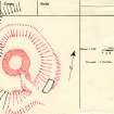
The remains of this broch, which has been reduced to little more than a mound of rubble, stand in the centre of an outer enclosure occupying the summit of a hillock overlooking the haughland on the E side of the River Naver. The outer enclosure measures about 37m from N to S by 28m transversely (0.08ha) within a rampart that barely rises above the level of the interior but drops up to 3.5m to the bottom of an external ditch which can be traced round the broch everywhere except on the steep western flank; a counterscarp bank is also present on the E. The entrance is on the SE, forming a hollow cutting through the rim of the hillock to approach the entrance of the broch; on its NE side it is flanked by a low bank.The relationship between the broch and the surrounding defences is unknown.
Information from An Atlas of Hillforts of Great Britain and Ireland – 31 May 2016. Atlas of Hillforts SC2804

