
Port William, Main Street, Harbour


Harbour (19th Century)
Site Name Port William, Main Street, Harbour
Classification Harbour (19th Century)
Alternative Name(s) Killantrae Burn; Port William Harbour; The Square; Pier, Gateway And Gateway Boundary Walls; Luce Bay; Solway Firth
Canmore ID 62828
Site Number NX34SW 20
NGR NX 33772 43758
Datum OSGB36 - NGR
Permalink http://canmore.org.uk/site/62828


- Council Dumfries And Galloway
- Parish Mochrum
- Former Region Dumfries And Galloway
- Former District Wigtown
- Former County Wigtownshire
NX34SW 20.00 33772 43758
Harbour [NAT] (name centred NX 3374 4376)
OS 1:10,000 map, 1983.
NX34SW 20.01 NX 33701 43773 to NX c. 33796 43854 North Pier
NX34SW 20.02 NX 33674 43749 to NX c. 33814 43690 South Pier and Quay
NX34SW 20.03 NX 33678 43745 South Pier, Light (Beacon)
NX34SW 24.04 NX 33680 43732 Gateway
See also:
NX34SW 14 NX 33839 43635 Store 1
NX34SW 15 NX 33811 43664 Store 2
NX34SW 16 NX 33787 43685 Store 3
Location formerly cited as NX 33750 43730.
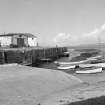
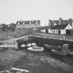
(Location cited as NX 337 437). Port William Harbour, built c. 1800. The quayed mouth of the Killantrae Burn, with a small basin at the landward end. The quaying is on the south side, terminating in a short pier, and the work is executed mainly in coursed rubble. There are some one- and two-storey stores on the quay, of 19th century origin, and stone walls and gate-posts at the entrance.
J R Hume 1976.
(Location cited as [NX] 336 436). Port William. Port William harbour originated as the mouth of the Killantrae Burn, now diverted to discharge across the pebbly beach a short distance to the S. Before its diversion, the burn skirted the rocky bluff now adapted as a public park, crossed the area of made ground occupied by The Square, and ran out into the narrow, curving and sharp-ended tidal inlet that now forms the harbour. The point of diversion, behind the Monreith Arms Hotel, appears quite clearly on the ground as well as on the large-scale OS map.
A good deal of information is available rewarding the harbour's development, but some important points go unmentioned, and consequently the following outline cannot be more than tentative. About 1776, a 'small neat village' was founded by Sir William Maxwell of Monreith [OSA], consisting of a row of low houses fronting on the sea. This was probably the forerunner of Main St. The same authority states that in 1796 a small but commodious and safe harbour existed, sheltered by the land on W, N and E but apparently open to the S and SW, as the writer goes on to mention 'a strong wall or rampart, which has sometime been begun to defend the south'. This language implies that the harbour, to the writer's mind, consisted only of the innermost portion of the inlet, and that natural protection from the S extended no further than the area of slightly elevated ground now occupied by warehouses and other harbour-buildings. At the same time, it indicates that a work was then under construction to the W or NW of this area, designed to increase the length of the protected stretch of the inlet and no doubt the same as the breakwater which will be mentioned shortly.
So far so good, but it would brash to assume that Sir William Maxwell's village was the first habitation on the site. The convenient natural harbour provided by the mouth of the Killantrae Burn contrasts sharply with the inhospitable boulder-strewn foreshore that hems in so much of this coast; and it would hardly have been neglected by a local population in any way dependent on the sea. Again, the name Killantrae, if it means 'the church by the shore' may well point to a vanished church in a position analogous with that of the neighbouring Kirkmaiden (NX 365 399), and on that showing to a fishing or seafaring community of very ancient standing. Sir William Maxwell's initiative should therefore perhaps be regarded as a measure of reorganisation rather than as a completely new venture.
The next piece of evidence comes from a report of 1812, by R Buchanan, prepared at Sir William's instance. From this we learn that the burn had by now been diverted, though the date of this operation is not mentioned, and that the breakwater intended to protect the harbour-entrance from south-westerly seas, as noted in 1796, was still in existence. The reasons for deflecting the burn had been that it brought down alluvial gravel, which tended to block up the harbour, and that it undermined the inner part of the quay; but Buchanan points out that the inflow of gravel could have been checked by a suitable system of 'cascades', that the new burn-mouth was increasing the erosion of the beach and causing more loose material to drift towards the end of the breakwater, and that this latter was wrongly sited and thus helped the shifting gravel to accumulate in the harbour's entrance. He proposed the construction of a new pier with a head which curved inwards, apparently to supersede the offending breakwater; but his drawings are not published, and consequently the relationship of his pier to the 'strong wall or rampart' of 1796 remains uncertain. A small point of some interest emerges in his proposal that masonry blocks in the faces of the work should be laid obliquely, in order to minimise the lifting effect of the waves; a peculiarity observed at many sites of the early 19th century in other parts of the country.
Buchanan's report is followed by a blank of nearly thirty years, but in 1841 there appears an estimate, with specifications, by J Linn for 'constructing the proposed Pier of Port William Harbour'. This report is not fully informative as again the drawings are not reproduced, but at least it proves that the 'proposal' for building a pier had still not been realised. It may, however, be compared with a plan of 1845 by Commr. C G Robinson, RN, which marks a 'proposed extension' of the pier about 300ft [91.5m] long with a circular head, this last feature corresponding with one mentioned by Linn. Nor was the end of the period of delays, as the Parliamentary Report of 1847 still speaks of 'proposals' to extend the 'jetty', then 360ft [109.8m] long but falling 300ft [91.5m] short of the low-water mark. By 1848, however, when the survey was made for the earliest edition of the 6-inch OS map, an extension had been built, which is generally comparable with the one shown by Robinson, though its outer end is not circular but cut off somewhat obliquely, and is also slightly inturned. (Dimensions cannot usefully be compared on account of the small scale of Robinson's plan). The plan further marks a warping-buoy in the deeper water outside. The harbour of 1847 gave 17ft [5.2m] of water at high springs and had an entrance 100ft [30.5m] wide; it was built by subscription and did a considerable local trade.
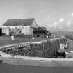
The modern harbour perpetuates, with the addition of the extended pier, the general arrangements that preceded it, consisting, as before, of a curving, finger-like inlet ending in a small and sharply pointed pocket. The concave N face of the combined [S] pier and quay now measures about 740ft [225.6m] in length, of which the pier accounts for some 230ft [70.1m], being itself 45ft [13.7m] wide except for a short extension turning N at its outer end. From the inner end of the pier, the quay widens out to coalesce with the area occupied by the harbour buildings, the SW side of which is revetted where it abuts on the beach outside. The strip of quay that forms the harbour frontage N of the buildings leads to a monumental entrance [NX34SW 20.04] opening into The Square, balancing another into South Street S of the buildings.
Alterations and improvements effected at various dates have disguised most structural details, but a few conspicuous features remain for comment - for example, the wall, about 7ft [2.1m] high that runs along the pier's S side and end; a pair of ornamental finials that rise above the wall at the outer corners; and a remarkable series of stone bollards carved to represent dwarf columns with bases and capitals. One example of this type was found at Isle of Whithorn (NX43NE 27) but none at any other site. One of the wooden bollards is also unusual, in consisting of part of a log and not the butt of a trunk.
A final noteworthy point in this harbour's history is its connection with what was evidently a flourishing contraband trade. Clone Farm [High Clone NX 339 457, Low Clone NX 336 452] for example, about a mile N of Port William (at NX 339 457) was the local headquarters of the Manx smuggling firm of Morrison, Gault and Co, probably in the 1770's, and had cellars for concealing its goods. A similar arrangement was in force at Balcary, in the Stewartry, though there the company (Clark, Grain and Quirk) built the headquarters itself. Again, in 1777, the crews of two armed luggers forced a party of 25 soldiers to allow them to land their cargo, rewarding them duly with 36 casks of spirits. A military and customs post was established at Port William in 1788, and smuggling was believed to have been 'largely' put down by 1796. The barracks of the Customs force served for many years as the stables of the Monreith Hotel, and its shell was only demolished in 1978.
A Graham 1979 (visited 1978).

