|
Prints and Drawings |
WGD 4/1 |
Records of the Royal Commission on the Ancient and Historical Monuments of Scotland (RCAHMS), Edinbu |
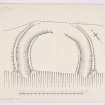
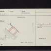
RCAHMS Marginal Land Survey inked plan, |
c. 1955 |
Item Level |
|
|
Manuscripts |
MS 36/173 |
Records of the Royal Commission on the Ancient and Historical Monuments of Scotland (RCAHMS), Edinbu |
Field notebook of K A Steer (RCAHMS). 'S6 - Kirkcudbright, Wigtown'. |
17/5/1951 |
Item Level |
|
 |
On-line Digital Images |
DP 151580 |
Records of the Royal Commission on the Ancient and Historical Monuments of Scotland (RCAHMS), Edinbu |
RCAHMS Marginal Land Survey inked plan, |
c. 1955 |
Item Level |
|
|
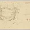
Prints and Drawings |
WGD 4/2 |
Records of the Royal Commission on the Ancient and Historical Monuments of Scotland (RCAHMS), Edinbu |
RCAHMS Marginal Land Survey pencil plane table plan and profile, |
10/10/1955 |
Item Level |
|
 |
On-line Digital Images |
DP 151581 |
Records of the Royal Commission on the Ancient and Historical Monuments of Scotland (RCAHMS), Edinbu |
RCAHMS Marginal Land Survey pencil plane table plan and profile, |
10/10/1955 |
Item Level |
|
 |
Digital Files (Non-image) |
WP 000786 |
Records of the Royal Commission on the Ancient and Historical Monuments of Scotland (RCAHMS), Edinbu |
Scanned copy of RCAHMS Marginal Land Survey unpublished typescripts (Wigtonshire). |
1951 |
Item Level |
|
 |
Digital Files (Non-image) |
WP 003888 |
Publications by the Royal Commission on the Ancient and Historical Monuments of Scotland |
Exploring Scotland's Heritage: Dumfries and Galloway |
1986 |
Item Level |
|
 |
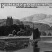
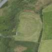
On-line Digital Images |
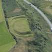
DP 261076 |
Historic Environment Scotland |
Oblique aerial view. |
12/7/2017 |
Item Level |
|
 |
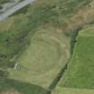
On-line Digital Images |
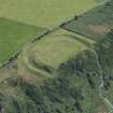
DP 261077 |
Historic Environment Scotland |
Oblique aerial view. |
12/7/2017 |
Item Level |
|
 |
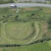
On-line Digital Images |
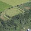
DP 261078 |
Historic Environment Scotland |
Oblique aerial view. |
12/7/2017 |
Item Level |
|
 |
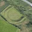
On-line Digital Images |
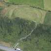
DP 261079 |
Historic Environment Scotland |
Oblique aerial view. |
12/7/2017 |
Item Level |
|
 |
On-line Digital Images |
DP 261080 |
Historic Environment Scotland |
Oblique aerial view. |
12/7/2017 |
Item Level |
|
 |
On-line Digital Images |
DP 261081 |
Historic Environment Scotland |
Oblique aerial view. |
12/7/2017 |
Item Level |
|
 |
On-line Digital Images |
DP 261082 |
Historic Environment Scotland |
Oblique aerial view. |
12/7/2017 |
Item Level |
|
 |
On-line Digital Images |
DP 261083 |
Historic Environment Scotland |
Oblique aerial view. |
12/7/2017 |
Item Level |
|
 |
On-line Digital Images |
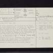
SC 2463371 |
Records of the Ordnance Survey, Southampton, Hampshire, England |
Barsalloch Point, NX34SW 1, Ordnance Survey index card, page number 1, Recto |
1958 |
Item Level |
|
 |
On-line Digital Images |
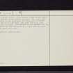
SC 2463372 |
Records of the Ordnance Survey, Southampton, Hampshire, England |
Barsalloch Point, NX34SW 1, Ordnance Survey index card, page number 2, Verso |
1958 |
Item Level |
|
 |
On-line Digital Images |
SC 2463373 |
Records of the Ordnance Survey, Southampton, Hampshire, England |
Barsalloch Point, NX34SW 1, Ordnance Survey index card, Recto |
1958 |
Item Level |
|
 |
On-line Digital Images |
SC 2463374 |
Records of the Ordnance Survey, Southampton, Hampshire, England |
Barsalloch Point, NX34SW 1, Ordnance Survey index card, Recto |
1958 |
Item Level |
|
|
All Other |
551 166/1/1 |
Records of the Ordnance Survey, Southampton, Hampshire, England |
Archaeological site card index ('495' cards) |
1947 |
Sub-Group Level |
|


