
Pricing Change
New pricing for orders of material from this site will come into place shortly. Charges for supply of digital images, digitisation on demand, prints and licensing will be altered.
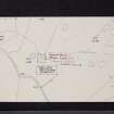
Moure Castle


Castle (Medieval)
Site Name Moure Castle
Classification Castle (Medieval)
Alternative Name(s) Dowies; 'principal Mansion Of Mowr'
Canmore ID 62760
Site Number NX34SE 18
NGR NX 3816 4333
Datum OSGB36 - NGR
Permalink http://canmore.org.uk/site/62760


- Council Dumfries And Galloway
- Parish Glasserton
- Former Region Dumfries And Galloway
- Former District Wigtown
- Former County Wigtownshire
NX34SE 18 3816 4333.
(NX 3816 4333) Supposed Site of (NAT)
Moure Castle (NR)
OS 25" map (1906)
The site of Moure Castle, which Reid suggests was not a stone-built tower, but a stockaded manor-house, is now a mound with a jumble of stones overgrown with weeds. It was in possession of Edward Maxwell c.1450; he came into the property through marriage to one of the de Mundeville family. The "manor of Mowir" is mentioned in 1564, and the "principal mansion of Mowr" in 1573. c.1600, this building was superseded by Dowies (see NX34SE 19), though its name also transferred to the other building.
An earlier name for the residence, in 1482, when in possession of the de Mundevilles, was Ballingrene, or in 1483, Ballingray.
R C Reid 1948
Dowies (NX34SE 19) stands on the edge of a boggy meadow, which appears to have once been a loch. On the other side, on a knoll still called Castlehill, the foundations of a considerable building are plainly to be traced, but there is no tradition as to when, or by whom, it was inhabited.
In a wood about 1/4 mile off are the foundations of another building.
P H M'Kerlie 1870
Moure Castle is now a shell, and comprises a rubble wall 1.6m wide and up to 1m high with a gap on either side of the SW corner. The interior contains turf-covered foundations of 3 buildings the main one of which measures 14m x 5.5m. There are no foundations evident in either Court Hill Plantation or the now felled High Drumfad Wood.
Surveyed at 1/2500.
Visited by OS (IA) 31 January 1973 .
See also: NX34SE 19 Old Place of Monreith

