
High Letterpin


Settlement (Iron Age)
Site Name High Letterpin
Classification Settlement (Iron Age)
Canmore ID 62089
Site Number NX19SE 2
NGR NX 19414 92118
Datum OSGB36 - NGR
Permalink http://canmore.org.uk/site/62089


- Council South Ayrshire
- Parish Girvan
- Former Region Strathclyde
- Former District Kyle And Carrick
- Former County Ayrshire
NX19SE 2 1942 9211.
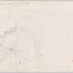
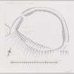
NX 1942 9211. The remains of an oval earthwork occupy the crest of a ridge and measure 56m N-S by 60m within a single earthen bank with external ditch.
The bank, now grass-covered with no sign of stone revetting, is 4m broad, 0.7m in maximum internal height and 1.5m in maximum external height, which is on the west. It can be traced all round except on the steep southside, where only the artificial terrace on which the rampart was carried along the face of the scarp is still partly visible. The ditch is 7m wide and 1.5m deep below the crest of the bank, its course being distinct on the west and east and faint on the north. On the west there is a well-defined entrance 4m wide, approached by a causeway 4.5m broad, and faint indications of another on the east.
The interior is featureless.
This is not simply a stock enclosure but has been designed for habitation although only excavation can determine its date (RCAHMS TS, 3 August 1954).
Visited by OS (JLD) 25 July 1956
A probable Iron Age settlement, generally as described in report above. The ditch is only apparent on the E and W, although faint traces can be seen on the N. The interior is featureless.
Surveyed at 1:10 000.
Visited by OS (SFS) 2 February 1976
Field Visit (30 August 1954)
This site was included within the RCAHMS Marginal Land Survey (1950-1962), an unpublished rescue project. Site descriptions, organised by county, are available to view online - see the searchable PDF in 'Digital Items'. These vary from short notes, to lengthy and full descriptions. Contemporary plane-table surveys and inked drawings, where available, can be viewed online in most cases - see 'Digital Images'. The original typecripts, notebooks and drawings can also be viewed in the RCAHMS search room.
Information from RCAHMS (GFG) 19 July 2013.
Reference (1957)
This site is noted in the ‘List of monuments discovered during the survey of marginal land (1951-5)’ (RCAHMS 1957, xiv-xviii).
Information from RCAHMS (GFG), 24 October 2012.
Field Visit (June 1982)
High Letterpin NX 194 921 NX19SE 2
This earthwork is situated on the crest of a ridge 700m NW of High Letterpin farmhouse. It is oval, measuring 61 m by 50m within a bank (5m thick by 0.5m high) and external ditch (6m broad by 0.5m deep), and there is a probable entrance on the WSW.
RCAHMS 1983, visited June 1982
(NMRS, AYD/15/1-2).
Note (2 May 2014 - 23 May 2016)
This enclosure is situated on the W spur of this ridge, and exploits a steep scarp on its S flank to provide protection. Elsewhere it is bounded by a rampart, which is typically spread about 5m in thickness by 0.5m in height, but on the W stands some 1.5m above the bottom of an external ditch 6m in breadth by 0.5m in depth. Slightly oval on plan, the featureless interior measures 61m from E to W by 50m transversely; the entrance is on the WNW.
Information from An Atlas of Hillforts of Great Britain and Ireland – 23 May 2016. Atlas of Hillforts SC0798

